
Topografische Karte Vernouillet
Interaktive Karte
Klicken Sie auf die Karte, um die Höhe anzuzeigen.
Über diese Karte
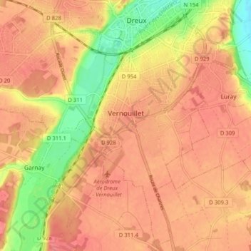
Name: Topografische Karte Vernouillet, Höhe, Relief.
Durchschnittliche Höhe: 124 m
Minimale Höhe: 80 m
Maximale Höhe: 145 m
Andere topografische Karten
Klicken Sie auf eine Karte, um ihre Topografie, ihre Höhe und ihr Relief anzuzeigen.
Montigny-le-Chartif
France > Centre-Val de Loire > Eure-et-Loir
Montigny-le-Chartif, Nogent-le-Rotrou, Eure-et-Loir, Centre-Val de Loire, France métropolitaine, 28120, France
Durchschnittliche Höhe: 187 m
Le Bois Billard
France > Centre-Val de Loire > Eure-et-Loir > Favières
Le Bois Billard, Favières, Dreux, Eure-et-Loir, Centre-Val de Loire, France métropolitaine, 28170, France
Durchschnittliche Höhe: 236 m
Beaumont-les-Autels
France > Centre-Val de Loire > Eure-et-Loir
Beaumont-les-Autels, Nogent-le-Rotrou, Eure-et-Loir, Centre-Val de Loire, France métropolitaine, 28480, France
Durchschnittliche Höhe: 231 m
La Morte
France > Centre-Val de Loire > Eure-et-Loir > Bailleau-Armenonville
La Morte, Bailleau-Armenonville, Chartres, Eure-et-Loir, Centre-Val de Loire, France métropolitaine, 28320, France
Durchschnittliche Höhe: 138 m
Favières
France > Centre-Val de Loire > Eure-et-Loir
Favières, Dreux, Eure-et-Loir, Centre-Val de Loire, France métropolitaine, 28170, France
Durchschnittliche Höhe: 236 m
Les Ressuintes
France > Centre-Val de Loire > Eure-et-Loir > Les Ressuintes
Les Ressuintes, Dreux, Eure-et-Loir, Centre-Val de Loire, France métropolitaine, 28340, France
Durchschnittliche Höhe: 253 m
Cloyes-les-Trois-Rivières
France > Centre-Val de Loire > Eure-et-Loir > Cloyes-les-Trois-Rivières
Cloyes-les-Trois-Rivières, Châteaudun, Eure-et-Loir, Centre-Val de Loire, France métropolitaine, 28220, France
Durchschnittliche Höhe: 142 m
Chartres
France > Centre-Val de Loire > Eure-et-Loir
Chartres, Eure-et-Loir, Centre-Val de Loire, France métropolitaine, 28000, France
Durchschnittliche Höhe: 150 m
Saint-Lucien
France > Centre-Val de Loire > Eure-et-Loir
Saint-Lucien, Dreux, Eure-et-Loir, Centre-Val de Loire, France métropolitaine, 28210, France
Durchschnittliche Höhe: 139 m