
Topografische Karte Wheeler Peak Glacier
Interaktive Karte
Klicken Sie auf die Karte, um die Höhe anzuzeigen.
Über diese Karte
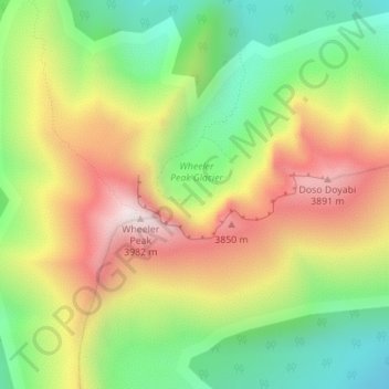
Name: Topografische Karte Wheeler Peak Glacier, Höhe, Relief.
Durchschnittliche Höhe: 3.500 m
Minimale Höhe: 3.106 m
Maximale Höhe: 3.972 m
Andere topografische Karten
Klicken Sie auf eine Karte, um ihre Topografie, ihre Höhe und ihr Relief anzuzeigen.
Winnemucca
USA > Nevada > Winnemucca
Winnemucca, Humboldt County, Nevada, 89445, USA
Durchschnittliche Höhe: 1.356 m
Sunrise Manor
USA > Nevada > Sunrise Manor
Sunrise Manor, Clark County, Nevada, USA
Durchschnittliche Höhe: 593 m
Jeff Davis Peak
Jeff Davis Peak, White Pine County, Nevada, USA
Durchschnittliche Höhe: 3.432 m
Snake Range
Snake Range, Great Basin National Park, White Pine County, Nevada, USA
Durchschnittliche Höhe: 1.984 m
Ruby Mountains
Ruby Mountains, National Forest Development Road 343 Trail, Elko County, Nevada, USA
Durchschnittliche Höhe: 1.962 m
Boulder City
USA > Nevada > Boulder City
Boulder City, Clark County, Nevada, 89005, USA
Durchschnittliche Höhe: 659 m
North Jackson Mountains Wilderness Area
North Jackson Mountains Wilderness Area, Jackson Creek Ranch Road, Humboldt County, Nevada, USA
Durchschnittliche Höhe: 1.747 m
Red Rock Canyon National Conservation Area
USA > Nevada > Mountain Springs
Red Rock Canyon National Conservation Area, NV 160, Mountain Springs, Clark County, Nevada, USA
Durchschnittliche Höhe: 1.361 m
Mount Augusta
Mount Augusta, Churchill County, Nevada, USA
Durchschnittliche Höhe: 2.752 m