
Topografische Karte Emmarentia Dam
Interaktive Karte
Klicken Sie auf die Karte, um die Höhe anzuzeigen.
Über diese Karte
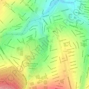
Name: Topografische Karte Emmarentia Dam, Höhe, Relief.
Durchschnittliche Höhe: 1.611 m
Minimale Höhe: 1.557 m
Maximale Höhe: 1.668 m
Andere topografische Karten
Klicken Sie auf eine Karte, um ihre Topografie, ihre Höhe und ihr Relief anzuzeigen.
Klipriviersberg Nature Reserve
South Africa > Gauteng > City of Johannesburg Metropolitan Municipality > Johannesburg
Klipriviersberg Nature Reserve, Ruins Trail, Johannesburg Ward 23, Johannesburg, City of Johannesburg Metropolitan Municipality, Gauteng, 2001, South Africa
Durchschnittliche Höhe: 1.634 m
Eastleigh Spruit
South Africa > Gauteng > City of Johannesburg Metropolitan Municipality > Johannesburg
Eastleigh Spruit, Rembrandtpark, Johannesburg Ward 81, Johannesburg, City of Johannesburg Metropolitan Municipality, Gauteng, 2001, South Africa
Durchschnittliche Höhe: 1.586 m
Chartwell Gardens
South Africa > Gauteng > City of Johannesburg Metropolitan Municipality > Johannesburg
Chartwell Gardens, Killarney, Johannesburg Ward 73, Johannesburg, City of Johannesburg Metropolitan Municipality, Gauteng, 2001, South Africa
Durchschnittliche Höhe: 1.703 m
Rose Gardens
South Africa > Gauteng > City of Johannesburg Metropolitan Municipality > Johannesburg
Rose Gardens, Emmarentia, Johannesburg Ward 88, Johannesburg, City of Johannesburg Metropolitan Municipality, Gauteng, 2001, South Africa
Durchschnittliche Höhe: 1.613 m