
Topografische Karte McIntosh
Interaktive Karte
Klicken Sie auf die Karte, um die Höhe anzuzeigen.
Über diese Karte
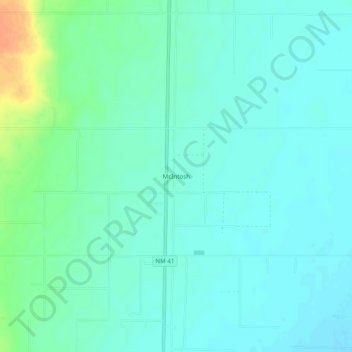
Name: Topografische Karte McIntosh, Höhe, Relief.
Durchschnittliche Höhe: 1.875 m
Minimale Höhe: 1.866 m
Maximale Höhe: 1.903 m
Andere topografische Karten
Klicken Sie auf eine Karte, um ihre Topografie, ihre Höhe und ihr Relief anzuzeigen.
Estancia
United States > New Mexico > Torrance County
Estancia, Torrance County, New Mexico, 87016, United States
Durchschnittliche Höhe: 1.866 m
Mountainair
United States > New Mexico > Torrance County
Mountainair, Torrance County, New Mexico, 87036, United States
Durchschnittliche Höhe: 1.991 m
Estancia
United States > New Mexico > Torrance County > Estancia
Estancia, Torrance County, New Mexico, 87016, United States
Durchschnittliche Höhe: 1.868 m
Moriarty
United States > New Mexico > Torrance County
Moriarty, Torrance County, New Mexico, 87035, United States
Durchschnittliche Höhe: 1.898 m
Manzano Mountains State Park
United States > New Mexico > Torrance County
Manzano Mountains State Park, Torrance County, New Mexico, United States
Durchschnittliche Höhe: 2.211 m