
Topografische Karte Barcelonnette
Interaktive Karte
Klicken Sie auf die Karte, um die Höhe anzuzeigen.
Barcelonnette
Barcelonnette is situated in the wide and fertile Ubaye Valley, of which it is the largest town. It lies at an elevation of 1132 m (3717 ft) on the right bank of the Ubaye River, and is surrounded by mountains which reach peaks of over 3000 m; the tallest of these is the Needle of Chambeyron at 3412 m. Barcelonnette is situated 210 km from Turin, 91 km from Nice and 68 km from Gap.
Über diese Karte
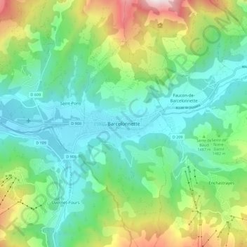
Name: Topografische Karte Barcelonnette, Höhe, Relief.
Durchschnittliche Höhe: 1.494 m
Minimale Höhe: 1.103 m
Maximale Höhe: 2.479 m