
Spenden
Rüsten Sie sich für Ihr nächstes Abenteuer:
Als Amazon-Partner erhält diese Website eine Provision für qualifizierte Käufe, ohne zusätzliche Kosten für Sie.
Topografische Karte Post Falls
Klicken Sie auf die Karte, um die Höhe anzuzeigen.
Spenden
Rüsten Sie sich für Ihr nächstes Abenteuer:
Als Amazon-Partner erhält diese Website eine Provision für qualifizierte Käufe, ohne zusätzliche Kosten für Sie.
Post Falls
Post Falls features a varied and distinctive topography characterized by its placement on the Rathdrum Prairie, which lies at an elevation of approximately 2,182 feet (665 meters) above sea level. This prairie is surrounded by rolling hills and rugged terrain that gradually rise towards the nearby Rocky Mountains to the east. The Spokane River runs through the city, creating dramatic waterfalls that enhance the area's natural beauty and provide a vibrant ecosystem. The landscape transitions from flat agricultural land in the prairie to more rugged and wooded areas as one moves towards the mountains, making it a region rich in both scenic vistas and recreational opportunities.
Spenden
Rüsten Sie sich für Ihr nächstes Abenteuer:
Als Amazon-Partner erhält diese Website eine Provision für qualifizierte Käufe, ohne zusätzliche Kosten für Sie.
Über diese Karte
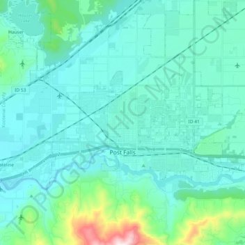
Name: Topografische Karte Post Falls, Höhe, Relief.
Ort: Post Falls, Kootenai County, Idaho, 83877, United States (47.69255 -117.04170 47.75945 -116.85641)
Durchschnittliche Höhe: 710 m
Minimale Höhe: 619 m
Maximale Höhe: 1.295 m
Spenden
Rüsten Sie sich für Ihr nächstes Abenteuer:
Als Amazon-Partner erhält diese Website eine Provision für qualifizierte Käufe, ohne zusätzliche Kosten für Sie.
Andere topografische Karten
Klicken Sie auf eine Karte, um ihre Topografie, ihre Höhe und ihr Relief anzuzeigen.
Spenden
Rüsten Sie sich für Ihr nächstes Abenteuer:
Als Amazon-Partner erhält diese Website eine Provision für qualifizierte Käufe, ohne zusätzliche Kosten für Sie.
Bayview
United States > Idaho > Kootenai County
Bayview is an unincorporated community in the northwest United States, located in Kootenai County, Idaho, north of Coeur d'Alene. On the southwest shore of Lake Pend Oreille, Bayview is seven miles (11 km) east-northeast of Athol. The community is served by State Highway 54 and a post office with ZIP code…
Durchschnittliche Höhe: 733 m
Spenden
Rüsten Sie sich für Ihr nächstes Abenteuer:
Als Amazon-Partner erhält diese Website eine Provision für qualifizierte Käufe, ohne zusätzliche Kosten für Sie.