
Topografische Karte Area G (Saltair / Gulf Islands)
Interaktive Karte
Klicken Sie auf die Karte, um die Höhe anzuzeigen.
Über diese Karte
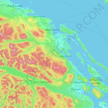
Name: Topografische Karte Area G (Saltair / Gulf Islands), Höhe, Relief.
Durchschnittliche Höhe: 282 m
Minimale Höhe: 0 m
Maximale Höhe: 1.579 m
Andere topografische Karten
Klicken Sie auf eine Karte, um ihre Topografie, ihre Höhe und ihr Relief anzuzeigen.
Thetis Island
Canada > British Columbia > Cowichan Valley Regional District > Area G (Saltair / Gulf Islands) > Spune’luxutth
Thetis Island, Spune’luxutth, Area G (Saltair / Gulf Islands), Cowichan Valley Regional District, British Columbia, Canada
Durchschnittliche Höhe: 16 m
Saltair
Canada > British Columbia > Cowichan Valley Regional District > Area G (Saltair / Gulf Islands) > Saltair
Saltair, Area G (Saltair / Gulf Islands), Cowichan Valley Regional District, British Columbia, V9G 2A4, Canada
Durchschnittliche Höhe: 66 m