
Topografische Karte Seguin Township
Interaktive Karte
Klicken Sie auf die Karte, um die Höhe anzuzeigen.
Über diese Karte
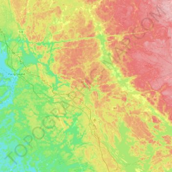
Name: Topografische Karte Seguin Township, Höhe, Relief.
Durchschnittliche Höhe: 247 m
Minimale Höhe: 172 m
Maximale Höhe: 336 m
Andere topografische Karten
Klicken Sie auf eine Karte, um ihre Topografie, ihre Höhe und ihr Relief anzuzeigen.
Ellsmere Island
Canada > Ontario > Parry Sound District > The Archipelago Township
Ellsmere Island, The Archipelago Township, Parry Sound District, Central Ontario, Ontario, Canada
Durchschnittliche Höhe: 197 m
Novar
Canada > Ontario > Parry Sound District > Perry Township
Novar, Perry Township, Parry Sound District, Central Ontario, Ontario, P0A 1R0, Canada
Durchschnittliche Höhe: 348 m
Doe Lake
Canada > Ontario > Parry Sound District > Ryerson Township
Doe Lake, Ryerson Township, Parry Sound District, Central Ontario, Ontario, Canada
Durchschnittliche Höhe: 311 m
McKellar
Canada > Ontario > Parry Sound District > McKellar Township
McKellar, McKellar Township, Parry Sound District, Central Ontario, Ontario, P0G 1C0, Canada
Durchschnittliche Höhe: 250 m
Carson Bay
Canada > Ontario > Parry Sound District > The Archipelago Township
Carson Bay, The Archipelago Township, Parry Sound District, Central Ontario, Ontario, Canada
Durchschnittliche Höhe: 187 m
Parry Sound
Canada > Ontario > Parry Sound District > Parry Sound
Parry Sound, Parry Sound District, Central Ontario, Ontario, P2A 1B2, Canada
Durchschnittliche Höhe: 202 m
Island Lake
Canada > Ontario > Parry Sound District
Island Lake, Parry Sound District, Central Ontario, Ontario, Canada
Durchschnittliche Höhe: 223 m
Emsdale
Canada > Ontario > Parry Sound District > Perry Township > Emsdale
Emsdale, Perry Township, Parry Sound District, Central Ontario, Ontario, P0A 1J0, Canada
Durchschnittliche Höhe: 349 m
Whitestone
Canada > Ontario > Parry Sound District
Whitestone, Parry Sound District, Central Ontario, Ontario, P0A 1G0, Canada
Durchschnittliche Höhe: 249 m