
Topografische Karte Inverness
Klicken Sie auf die Karte, um die Höhe anzuzeigen.
Über diese Karte
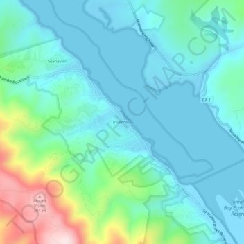
Name: Topografische Karte Inverness, Höhe, Relief.
Durchschnittliche Höhe: 82 m
Minimale Höhe: -4 m
Maximale Höhe: 401 m
Andere topografische Karten
Klicken Sie auf eine Karte, um ihre Topografie, ihre Höhe und ihr Relief anzuzeigen.
San Geronimo
United States > California > Marin County
San Geronimo (Spanish: San Gerónimo, meaning "St. Jerome") is a census-designated place (CDP) located in the San Geronimo Valley in Marin County, California in the United States. San Geronimo is located with Lagunitas-Forest Knolls to its west, Woodacre to its east, and 8 miles (13 km) southwest of downtown…
Durchschnittliche Höhe: 234 m
Corte Madera
United States > California > Marin County
Corte Madera (/ˈkɔːrtə məˈdɛrə/; Spanish for "Chop Wood") is an incorporated town in Marin County, California. Corte Madera is located 3.25 miles (5.2 km) south of San Rafael, at an elevation of 39 feet (12 m). The population was 10,222 at the 2020 census. The town was named after the Spanish…
Durchschnittliche Höhe: 52 m
Cascade Canyon Open Space Preserve
United States > California > Marin County > Fairfax > Manor
Durchschnittliche Höhe: 191 m
Tamalpais-Homestead Valley
United States > California > Marin County > Mill Valley
Durchschnittliche Höhe: 92 m