
Topografische Karte Kuelap
Interaktive Karte
Klicken Sie auf die Karte, um die Höhe anzuzeigen.
Über diese Karte
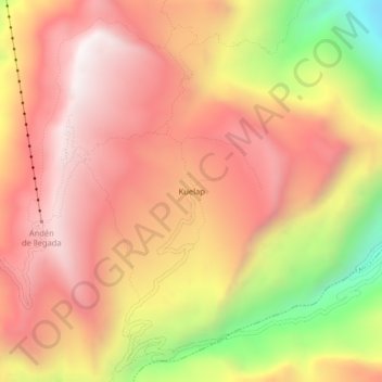
Name: Topografische Karte Kuelap, Höhe, Relief.
Ort: Kuelap, Tingo, Province of Luya, Amazonas, 01415, Peru (-6.44310 -77.93072 -6.40310 -77.89072)
Durchschnittliche Höhe: 2.600 m
Minimale Höhe: 1.823 m
Maximale Höhe: 3.065 m
Kuélap is located on a limestone ridge on top of a mountain at an elevation of 3000 metres, on the left bank of the Utcubamba River. It belongs to the district of Tingo, Luya Province, Amazonas. The area is covered with cloud forests, with a variety of trees, orchids and epiphytes. The protected zone covers an area of 218.33 ha (2.18 km2) and a buffer zone of 609.67 ha (6.10 km2), both protecting about 12 archaeological sites and the main site of Kuélap.
Andere topografische Karten
Klicken Sie auf eine Karte, um ihre Topografie, ihre Höhe und ihr Relief anzuzeigen.
Nuevo Tingo
Nuevo Tingo, Tingo, Province of Luya, Amazonas, 01415, Peru
Durchschnittliche Höhe: 2.007 m