
Topografische Karte Boyle County
Interaktive Karte
Klicken Sie auf die Karte, um die Höhe anzuzeigen.
Über diese Karte
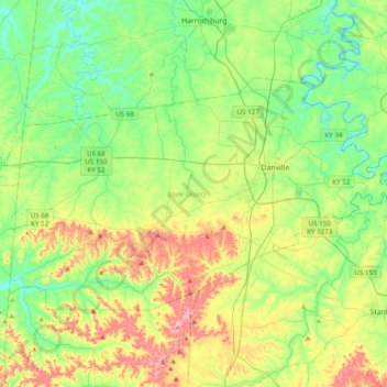
Name: Topografische Karte Boyle County, Höhe, Relief.
Ort: Boyle County, Kentucky, United States (37.53220 -85.03909 37.71703 -84.65175)
Durchschnittliche Höhe: 293 m
Minimale Höhe: 219 m
Maximale Höhe: 445 m
Andere topografische Karten
Klicken Sie auf eine Karte, um ihre Topografie, ihre Höhe und ihr Relief anzuzeigen.
Elizabethtown
United States > Kentucky > Hardin County
Elizabethtown, Hardin County, Kentucky, 42701, United States
Durchschnittliche Höhe: 241 m
Owensboro
United States > Kentucky > Daviess County
Owensboro, Daviess County, Kentucky, United States
Durchschnittliche Höhe: 123 m
Bowling Green
United States > Kentucky > Warren County
Bowling Green, Warren County, Kentucky, 42101, United States
Durchschnittliche Höhe: 169 m
Lexington
United States > Kentucky > Fayette County
Lexington, Fayette County, Kentucky, United States
Durchschnittliche Höhe: 281 m
Stanton
United States > Kentucky > Powell County
Stanton, Powell County, Kentucky, United States
Durchschnittliche Höhe: 215 m
Blood River
United States > Kentucky > Calloway County
Blood River, Calloway County, Kentucky, United States
Durchschnittliche Höhe: 126 m
Livingston County
Livingston County, Kentucky, United States
Durchschnittliche Höhe: 131 m
Kitts
United States > Kentucky > Harlan County
Kitts, Harlan County, Kentucky, 40801, United States
Durchschnittliche Höhe: 528 m
Johns Hill
United States > Kentucky > Campbell County > Wilder
Johns Hill, Wilder, Campbell County, Kentucky, 41099, United States
Durchschnittliche Höhe: 219 m
Nelson County
Nelson County, Kentucky, United States
Durchschnittliche Höhe: 207 m
Falmouth
United States > Kentucky > Pendleton County
Falmouth, Pendleton County, Kentucky, 41040, United States
Durchschnittliche Höhe: 187 m
Princeton
United States > Kentucky > Caldwell County > Princeton
Princeton, Caldwell County, Kentucky, 42445, United States
Durchschnittliche Höhe: 155 m
Thornhill
United States > Kentucky > Jefferson County > Thornhill
Thornhill, Jefferson County, Kentucky, United States
Durchschnittliche Höhe: 180 m
Rockcastle County
Rockcastle County, Kentucky, United States
Durchschnittliche Höhe: 348 m