
Spenden
Rüsten Sie sich für Ihr nächstes Abenteuer:
Als Amazon-Partner erhält diese Website eine Provision für qualifizierte Käufe, ohne zusätzliche Kosten für Sie.
Topografische Karte Nekhel
Klicken Sie auf die Karte, um die Höhe anzuzeigen.
Spenden
Rüsten Sie sich für Ihr nächstes Abenteuer:
Als Amazon-Partner erhält diese Website eine Provision für qualifizierte Käufe, ohne zusätzliche Kosten für Sie.
Nekhel
Nikhel (Arabic: نِخِل ; also spelled and pronounced Nikhl ) is administratively a city (though realistically more of a town) and the capital of the eponymous markaz (county) North Sinai Governorate, Egypt. It is located in the heart of the Sinai Peninsula bordered to its south by the South Sinai Governorate, and is bordered from the west by the Sinai side of the Suez governorate, from the east by the international border of Egypt with Israel, and from the north by Al-Hasana markaz. It is located at the skirts of al-Tih Mountains and foothills at an elevation of 420.6 m (1,380 ft). The coordinates of the city is 29°54'N; 33°45'E. In addition to the town of Nikhel, the markaz comprises 10 other towns and settlements: al-Contilla, Wadi al-Haj, Sadr al-Hitan, al-Tamad, Bir Grid, al-Khafaga, al-Buruk, al-Netila, Ein Twibah and al-Salam.
Spenden
Rüsten Sie sich für Ihr nächstes Abenteuer:
Als Amazon-Partner erhält diese Website eine Provision für qualifizierte Käufe, ohne zusätzliche Kosten für Sie.
Über diese Karte
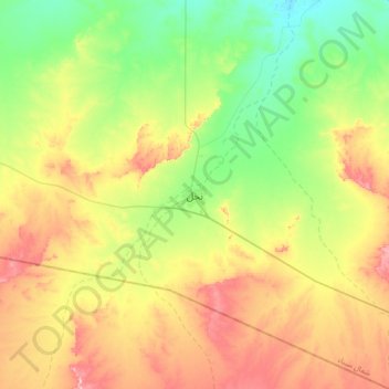
Name: Topografische Karte Nekhel, Höhe, Relief.
Ort: Nekhel, North Sinai, Egypt (29.75145 33.58599 30.07145 33.90599)
Durchschnittliche Höhe: 439 m
Minimale Höhe: 348 m
Maximale Höhe: 575 m
Spenden
Rüsten Sie sich für Ihr nächstes Abenteuer:
Als Amazon-Partner erhält diese Website eine Provision für qualifizierte Käufe, ohne zusätzliche Kosten für Sie.
Andere topografische Karten
Klicken Sie auf eine Karte, um ihre Topografie, ihre Höhe und ihr Relief anzuzeigen.
Spenden
Rüsten Sie sich für Ihr nächstes Abenteuer:
Als Amazon-Partner erhält diese Website eine Provision für qualifizierte Käufe, ohne zusätzliche Kosten für Sie.