
Topografische Karte Cedar Mountain
Interaktive Karte
Klicken Sie auf die Karte, um die Höhe anzuzeigen.
Über diese Karte
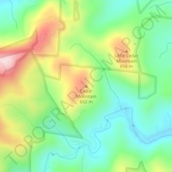
Name: Topografische Karte Cedar Mountain, Höhe, Relief.
Ort: Cedar Mountain, Burke County, North Carolina, United States (35.65036 -81.68598 35.65046 -81.68588)
Durchschnittliche Höhe: 533 m
Minimale Höhe: 405 m
Maximale Höhe: 751 m
Andere topografische Karten
Klicken Sie auf eine Karte, um ihre Topografie, ihre Höhe und ihr Relief anzuzeigen.
Gold
United States > North Carolina > Burke County
Gold, Burke County, North Carolina, 28680, United States
Durchschnittliche Höhe: 369 m
Morganton
United States > North Carolina > Burke County > Morganton
Morganton, Burke County, North Carolina, 28655, United States
Durchschnittliche Höhe: 355 m
Linville
United States > North Carolina > Burke County
Linville, Burke County, North Carolina, United States
Durchschnittliche Höhe: 412 m
Table Rock Mountain
United States > North Carolina > Burke County
Table Rock Mountain, Burke County, North Carolina, United States
Durchschnittliche Höhe: 807 m