Geolokalisieren

Topografische Karte Kisoro

Interaktive Karte

Klicken Sie auf die Karte, um die Höhe anzuzeigen.

Über diese Karte

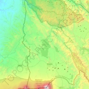
Name: Topografische Karte Kisoro, Höhe, Relief.

Ort: Kisoro, West-Region, Uganda (-1.38942 29.57343 -1.00664 29.82131)

Durchschnittliche Höhe: 1.943 m

Minimale Höhe: 1.069 m

Maximale Höhe: 4.084 m

Andere topografische Karten

Klicken Sie auf eine Karte, um ihre Topografie, ihre Höhe und ihr Relief anzuzeigen.

Fort Portal City

Uganda > West-Region

Fort Portal City, West-Region, Uganda

Durchschnittliche Höhe: 1.525 m

Dodos

Uganda > Amuria

Dodos, Amuria, Ost-Region, Uganda

Durchschnittliche Höhe: 1.091 m

Wol

Uganda > Agago

Wol, Agago, Nord-Region, Uganda

Durchschnittliche Höhe: 1.064 m

Kampala

Uganda > Zentral-Region

Kampala, Zentral-Region, Uganda

Durchschnittliche Höhe: 1.179 m

Buterere

Uganda > Rakai

Buterere, Rakai, Zentral-Region, Uganda

Durchschnittliche Höhe: 1.271 m

Bweyale

Uganda > Kiryandongo

Bweyale, Kiryandongo, West-Region, Uganda

Durchschnittliche Höhe: 1.094 m

Weismann

Uganda > Kasese

Weismann, Kasese, West-Region, Uganda

Durchschnittliche Höhe: 4.276 m

Atal

Uganda > Pader

Atal, Pader, Nord-Region, Uganda

Durchschnittliche Höhe: 1.010 m

Lima

Uganda > Arua

Lima, Logiri, Arua, Nord-Region, Uganda

Durchschnittliche Höhe: 1.449 m

London

Uganda > Oyam

London, Oyam, Nord-Region, Uganda

Durchschnittliche Höhe: 1.063 m

Tororo

Uganda > Tororo

Tororo, Ost-Region, Uganda

Durchschnittliche Höhe: 1.184 m

Kereku

Uganda > Luweero

Kereku, Luweero, Zentral-Region, Uganda

Durchschnittliche Höhe: 1.142 m

Komite

Uganda > Arua

Komite, Pajulu, Arua, Nord-Region, Uganda

Durchschnittliche Höhe: 1.220 m

Luwero

Uganda > Bugiri

Luwero, Bugiri, Ost-Region, Uganda

Durchschnittliche Höhe: 1.138 m

Kakuto

Uganda > Kyankwanzi

Kakuto, Kyankwanzi, Zentral-Region, Uganda

Durchschnittliche Höhe: 1.182 m

Kisoro

Uganda > Kisoro > Cyanika

Kisoro, Cyanika, Kisoro, West-Region, Uganda

Durchschnittliche Höhe: 1.911 m

K 2

Uganda > Zentral-Region > Kampala

K 2, Kampala, Zentral-Region, Uganda

Durchschnittliche Höhe: 1.193 m

Kampala

Uganda > Zentral-Region

Kampala, Zentral-Region, Uganda

Durchschnittliche Höhe: 1.179 m

Kashija

Uganda > Kisoro > Kashija

Kashija, Kisoro, West-Region, Uganda

Durchschnittliche Höhe: 1.996 m

Nyamagana

Uganda > Kisoro > Nyamagana

Nyamagana, Kisoro, West-Region, Uganda

Durchschnittliche Höhe: 1.828 m

Zentral-Region

Uganda

Zentral-Region, Uganda

Durchschnittliche Höhe: 1.134 m

Middle Portal

Uganda > Kasese

Middle Portal, Kasese, West-Region, Uganda

Durchschnittliche Höhe: 3.946 m

West-Region

Uganda

West-Region, Uganda

Durchschnittliche Höhe: 1.214 m

Ruwenzori-Gebirge

Uganda > Bundibugyo > Sindila

Ruwenzori-Gebirge, Bundibugyo, West-Region, Uganda

Durchschnittliche Höhe: 1.570 m

Amuru

Uganda > Amuru

Amuru, Nord-Region, Uganda

Durchschnittliche Höhe: 893 m

Yona Okot Spring

Uganda > Makindye

Yona Okot Spring, Nawuwongo Road, Namuwongo, Kibuli, Makindye, Kampala, Zentral-Region, 28487, Uganda

Durchschnittliche Höhe: 1.167 m

Kabale

Uganda > Kabale

Kabale, West-Region, Uganda

Durchschnittliche Höhe: 1.850 m

Albertsee

Uganda > Hoima > Hoima

Albertsee, Hoima, West-Region, Uganda

Durchschnittliche Höhe: 1.076 m

Kinanga

Uganda > Yumbe > Kinanga

Kinanga, Yumbe, Nord-Region, Uganda

Durchschnittliche Höhe: 898 m

Nwoya

Uganda

Nwoya, Nord-Region, Uganda

Durchschnittliche Höhe: 910 m

Kyogasee

Uganda > Amolatar

Kyogasee, Amolatar, Nord-Region, Uganda

Durchschnittliche Höhe: 1.056 m

Pader

Uganda > Pader

Pader, Nord-Region, Uganda

Durchschnittliche Höhe: 1.009 m

Rakai

Uganda

Rakai, Zentral-Region, Uganda

Durchschnittliche Höhe: 1.260 m

Oleni

Uganda > Arua > Oleni

Oleni, Arua, Nord-Region, Uganda

Durchschnittliche Höhe: 1.154 m

Paraa

Uganda > Arua > Paraa

Paraa, Arua, Nord-Region, Uganda

Durchschnittliche Höhe: 660 m

Luweero

Uganda > Luweero > Luweero

Luweero, Zentral-Region, Uganda

Durchschnittliche Höhe: 1.101 m

Kavango

Uganda > Nebbi

Kavango, Nebbi, Nord-Region, Uganda

Durchschnittliche Höhe: 620 m

Lolim

Uganda > Kaabong

Lolim, Kaabong, Nord-Region, Uganda

Durchschnittliche Höhe: 1.913 m

Kakuto

Uganda > Kiruhura > Kakuto

Kakuto, Kiruhura, West-Region, Uganda

Durchschnittliche Höhe: 1.281 m

Kasese

Uganda

Kasese, West-Region, Uganda

Durchschnittliche Höhe: 1.457 m

Pawor

Uganda > Arua > Pawor

Pawor, Arua, Nord-Region, Uganda

Durchschnittliche Höhe: 648 m

Sagitwe Volcano

Uganda > Kisoro

Sagitwe Volcano, Cyanika, Kisoro, West-Region, PO BOX 22, Uganda

Durchschnittliche Höhe: 1.980 m

Katwe-Kikorongo Volcanic Field

Uganda > Kasese > Kasese

Katwe-Kikorongo Volcanic Field, Kasese, West-Region, Uganda

Durchschnittliche Höhe: 1.069 m