
Topografische Karte Tutbury Castle
Interaktive Karte
Klicken Sie auf die Karte, um die Höhe anzuzeigen.
Über diese Karte
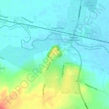
Name: Topografische Karte Tutbury Castle, Höhe, Relief.
Durchschnittliche Höhe: 66 m
Minimale Höhe: 52 m
Maximale Höhe: 107 m
Andere topografische Karten
Klicken Sie auf eine Karte, um ihre Topografie, ihre Höhe und ihr Relief anzuzeigen.
Uttoxeter
United Kingdom > England > East Staffordshire > Uttoxeter
Uttoxeter, Staffordshire, West Midlands, England, ST14 8HF, United Kingdom
Durchschnittliche Höhe: 108 m
Tutbury
United Kingdom > England > East Staffordshire > Tutbury
Tutbury, East Staffordshire, Staffordshire, West Midlands, England, DE13 9LS, United Kingdom
Durchschnittliche Höhe: 66 m
Wootton
United Kingdom > England > East Staffordshire > Wootton
Wootton, East Staffordshire, Staffordshire, West Midlands, England, DE6 2GW, United Kingdom
Durchschnittliche Höhe: 217 m
Wychnor
United Kingdom > England > East Staffordshire > Wychnor
Wychnor, East Staffordshire, Staffordshire, West Midlands, England, DE13 8BY, United Kingdom
Durchschnittliche Höhe: 58 m
Hanbury
United Kingdom > England > East Staffordshire > Hanbury
Hanbury, East Staffordshire, Staffordshire, West Midlands, England, DE13 8TP, United Kingdom
Durchschnittliche Höhe: 104 m
Dunstall
United Kingdom > England > East Staffordshire > Dunstall
Dunstall, East Staffordshire, Staffordshire, West Midlands, England, United Kingdom
Durchschnittliche Höhe: 79 m
Denstone
United Kingdom > England > East Staffordshire > Denstone
Denstone, East Staffordshire, Staffordshire, West Midlands, England, ST14 5GB, United Kingdom
Durchschnittliche Höhe: 118 m
Rolleston on Dove
United Kingdom > England > East Staffordshire > Rolleston on Dove
Rolleston on Dove, East Staffordshire, Staffordshire, West Midlands, England, DE13 9BE, United Kingdom
Durchschnittliche Höhe: 60 m
River Tean
United Kingdom > England > East Staffordshire
River Tean, East Staffordshire, Staffordshire, West Midlands, England, ST14 5AA, United Kingdom
Durchschnittliche Höhe: 89 m
Ellastone
United Kingdom > England > East Staffordshire
Ellastone, East Staffordshire, Staffordshire, West Midlands, England, United Kingdom
Durchschnittliche Höhe: 139 m
Winshill
United Kingdom > England > East Staffordshire
Winshill, East Staffordshire, Staffordshire, West Midlands, England, United Kingdom
Durchschnittliche Höhe: 75 m
River Swarbourn
United Kingdom > England > East Staffordshire
River Swarbourn, East Staffordshire, Staffordshire, West Midlands, England, DE13 8RU, United Kingdom
Durchschnittliche Höhe: 98 m