
Topografische Karte Davison Street
Interaktive Karte
Klicken Sie auf die Karte, um die Höhe anzuzeigen.
Über diese Karte
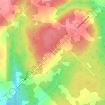
Name: Topografische Karte Davison Street, Höhe, Relief.
Durchschnittliche Höhe: 195 m
Minimale Höhe: 142 m
Maximale Höhe: 229 m
Andere topografische Karten
Klicken Sie auf eine Karte, um ihre Topografie, ihre Höhe und ihr Relief anzuzeigen.
Gaspereau Mountain
Canada > Nova Scotia > Municipality of the County of Kings > Forest Hill
Gaspereau Mountain, Forest Hill, Municipality of the County of Kings, Kings County, Nova Scotia, B4P 2R1, Canada
Durchschnittliche Höhe: 185 m