Geolokalisieren

Topografische Karte River Wear

Klicken Sie auf die Karte, um die Höhe anzuzeigen.

Über diese Karte

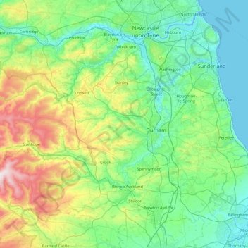
Name: Topografische Karte River Wear, Höhe, Relief.

Ort: River Wear, County Durham, North East England, England, DH1 3DA, United Kingdom (54.65969 -2.22205 54.91770 -1.36153)

Durchschnittliche Höhe: 148 m

Minimale Höhe: -2 m

Maximale Höhe: 668 m

Andere topografische Karten

Klicken Sie auf eine Karte, um ihre Topografie, ihre Höhe und ihr Relief anzuzeigen.

London

United Kingdom > England > London

Durchschnittliche Höhe: 42 m

Telford

United Kingdom > England > Telford and Wrekin

Durchschnittliche Höhe: 136 m

New Arley

United Kingdom > England > Warwickshire > North Warwickshire

Durchschnittliche Höhe: 141 m

Leeds

United Kingdom > England

Lying in the eastern foothills of the Pennines, there is a significant variation in elevation within the city's built-up area. The district ranges from 1,115 feet (340 m) in the far west on the slopes of Ilkley Moor to about 33 feet (10 m) where the rivers Aire and Wharfe cross the eastern boundary. Land rises…

Durchschnittliche Höhe: 94 m

Hebden Bridge

United Kingdom > England > Calderdale

Durchschnittliche Höhe: 277 m

Vielen Dank für die Unterstützung dieser Website ❤️
Spenden

Rüsten Sie sich für Ihr nächstes Abenteuer:

Als Amazon-Partner erhält diese Website eine Provision für qualifizierte Käufe, ohne zusätzliche Kosten für Sie.

Cambridge

United Kingdom > England > Cambridge

The city, like most of the UK, has a maritime climate highly influenced by the Gulf Stream. Located in the driest region of Britain, Cambridge's rainfall averages around 570 mm (22.44 in) per year, around half the national average, with some years occasionally falling into the semi-arid (under 500 mm (19.69…

Durchschnittliche Höhe: 18 m

City of London

United Kingdom > England > City of London > City of London

The elevation of the City ranges from sea level at the Thames to 21.6 metres (71 ft) at the junction of High Holborn and Chancery Lane. Two small but notable hills are within the historic core, Ludgate Hill to the west and Cornhill to the east. Between them ran the Walbrook, one of the many "lost" rivers or…

Durchschnittliche Höhe: 42 m

Halifax

United Kingdom > England > Calderdale

Topographically, Halifax is located in the south-eastern corner of the moorland region called the South Pennines. Halifax is situated about 4 miles (6 km) from the M62 motorway, close to Bradford and Huddersfield. The A641 road links the town with Brighouse, Bradford and Huddersfield. The Hebble Brook joins…

Durchschnittliche Höhe: 195 m

Tonbridge

United Kingdom > England > Kent > Tonbridge and Malling

Durchschnittliche Höhe: 52 m

Carlisle

United Kingdom > England > Cumberland

Durchschnittliche Höhe: 31 m

Brighton

United Kingdom > England > Brighton and Hove

Durchschnittliche Höhe: 64 m

Swindon

United Kingdom > England > Swindon

Swindon has an oceanic climate (Cfb in the Köppen climate classification), like the vast majority of the British Isles, with cool winters and warm summers. The nearest official weather station is RAF Lyneham, about 10 miles (16 km) west southwest of Swindon town centre. The weather station's elevation is 145…

Durchschnittliche Höhe: 108 m

Upper Harlestone

United Kingdom > England > Northamptonshire

Durchschnittliche Höhe: 109 m

Egypt

United Kingdom > England > Buckinghamshire > Farnham Royal

Durchschnittliche Höhe: 78 m

Acton

United Kingdom > England > Greater London

Durchschnittliche Höhe: 23 m

Jacksdale

United Kingdom > England > Nottinghamshire > Ashfield

Durchschnittliche Höhe: 105 m

Old Town

United Kingdom > England > Westmorland and Furness > High Hesket

Durchschnittliche Höhe: 129 m

Hough

United Kingdom > England > Cheshire East

Durchschnittliche Höhe: 62 m

Marchamley

United Kingdom > England > Shropshire

Durchschnittliche Höhe: 119 m

Nesscliffe

United Kingdom > England > Shropshire

Durchschnittliche Höhe: 84 m

Gill's Fold

United Kingdom > England > Brierley Hill

Durchschnittliche Höhe: 121 m

Plant's Green

United Kingdom > England > Sandwell > Old Hill

Durchschnittliche Höhe: 135 m

Lee Brockhurst

United Kingdom > England > Shropshire

Durchschnittliche Höhe: 96 m

Armitage

United Kingdom > England > Staffordshire > Lichfield

Durchschnittliche Höhe: 80 m

Vielen Dank für die Unterstützung dieser Website ❤️
Spenden

Rüsten Sie sich für Ihr nächstes Abenteuer:

Als Amazon-Partner erhält diese Website eine Provision für qualifizierte Käufe, ohne zusätzliche Kosten für Sie.

Heath Hayes

United Kingdom > England > Staffordshire > Cannock Chase

Durchschnittliche Höhe: 170 m

BN2 0QU

United Kingdom > England > Brighton and Hove > Brighton

Durchschnittliche Höhe: 44 m

Crawcrook

United Kingdom > England > Gateshead

Durchschnittliche Höhe: 76 m

Bilston

United Kingdom > England > Wolverhampton

Durchschnittliche Höhe: 148 m

Dawley

United Kingdom > England > Telford and Wrekin

Durchschnittliche Höhe: 142 m

Vielen Dank für die Unterstützung dieser Website ❤️
Spenden

Rüsten Sie sich für Ihr nächstes Abenteuer:

Als Amazon-Partner erhält diese Website eine Provision für qualifizierte Käufe, ohne zusätzliche Kosten für Sie.

Button Oak

United Kingdom > England > Shropshire

Durchschnittliche Höhe: 92 m

Mucklow Hill

United Kingdom > England > Dudley

Durchschnittliche Höhe: 170 m

Harpenden

United Kingdom > England > Harpenden

Durchschnittliche Höhe: 120 m

Matlock

United Kingdom > England > Derbyshire > Derbyshire Dales

Durchschnittliche Höhe: 213 m

Glossop

United Kingdom > England > Derbyshire > High Peak

Durchschnittliche Höhe: 284 m

Keswick

United Kingdom > England > Keswick

Durchschnittliche Höhe: 223 m

Chester

United Kingdom > England > Cheshire West and Chester

Durchschnittliche Höhe: 61 m

Royal Tunbridge Wells

United Kingdom > England > Kent > Tunbridge Wells

Durchschnittliche Höhe: 99 m

St Albans

United Kingdom > England > Hertfordshire > St Albans

St Albans was an ancient borough created following the dissolution of the monastery in 1539. It consisted of the ancient parish of St Albans (also known as the Abbey parish) and parts of St Michael and St Peter. The municipal corporation was reformed by the Municipal Corporations Act 1835 and the boundary was…

Durchschnittliche Höhe: 100 m

Richmond

United Kingdom > England > London

The town centre lies just below 33 ft (10m) above sea level. South of the town centre, rising from Richmond Bridge to an elevation of 165 ft (50m), is Richmond Hill. Just beyond the summit of Richmond Hill is Richmond Park, an area of 2,360 acres (9.55 km2; 3.7 sq mi) of wild heath and woodland originally…

Durchschnittliche Höhe: 17 m

York

United Kingdom > England > York

Durchschnittliche Höhe: 21 m

Leicester

United Kingdom > England > Leicestershire

Durchschnittliche Höhe: 109 m

Durham

United Kingdom > England > County Durham

Durchschnittliche Höhe: 119 m

Whitehill

United Kingdom > England > Staffordshire > Kidsgrove > Harriseahead

Durchschnittliche Höhe: 179 m

Worthen

United Kingdom > England > Shropshire

Durchschnittliche Höhe: 144 m

Baxenden

United Kingdom > England > Lancashire > Hyndburn

Durchschnittliche Höhe: 265 m

Buckley

United Kingdom > England > Milnrow

Durchschnittliche Höhe: 179 m

Leyhill Common

United Kingdom > England > Buckinghamshire

Durchschnittliche Höhe: 147 m

Newton Ferrers

United Kingdom > England > Devon > South Hams

Durchschnittliche Höhe: 58 m

Bantham

United Kingdom > England > Devon > South Hams > Thurlestone

Durchschnittliche Höhe: 35 m

Wetherlam

United Kingdom > England > Westmorland and Furness > Coniston

Durchschnittliche Höhe: 459 m

Shingle Street

United Kingdom > England > Suffolk > East Suffolk > Bawdsey

Durchschnittliche Höhe: 2 m

Kates Hill

United Kingdom > England > Dudley

Durchschnittliche Höhe: 178 m

Nutbourne

United Kingdom > England > West Sussex > Chichester

Durchschnittliche Höhe: 7 m

Whitehouse Common

United Kingdom > England > Birmingham > Sutton Coldfield

Durchschnittliche Höhe: 129 m

Chipping Barnet

United Kingdom > England > Greater London

Its name is very often abbreviated to just Barnet, which is also the name of the borough of which it forms a part; the town has been part of Greater London since 1965 after the abolition of Barnet Urban District then in Hertfordshire. Chipping Barnet is also the name of the Parliamentary constituency covering…

Durchschnittliche Höhe: 95 m

Huddersfield

United Kingdom > England > Kirklees

Durchschnittliche Höhe: 145 m

Leighton Buzzard

United Kingdom > England > Central Bedfordshire

Durchschnittliche Höhe: 103 m

Stourbridge

United Kingdom > England

Durchschnittliche Höhe: 113 m

Grimsby

United Kingdom > England > North East Lincolnshire

Durchschnittliche Höhe: 6 m

Folkestone

United Kingdom > England > Folkestone

Durchschnittliche Höhe: 46 m

Portsmouth

United Kingdom > England > Hampshire > Portsmouth

By road, Portsmouth lies 73.5 miles (118.3 km) from Central London, 49.5 miles (79.7 km) west of Brighton, and 22.3 miles (35.9 km) east of Southampton. Portsmouth is situated primarily on Portsea Island and is the United Kingdom's only island city, although parts of it have expanded onto the mainland. Gosport…

Durchschnittliche Höhe: 28 m

Enfield

United Kingdom > England

Durchschnittliche Höhe: 39 m

Melton Mowbray

United Kingdom > England > Leicestershire > Melton

Durchschnittliche Höhe: 103 m

Burton upon Trent

United Kingdom > England > Staffordshire > East Staffordshire

Burton is about 109 miles (175 km) north west of London, about 30 miles north east of Birmingham, the UK's second largest city and about 23 miles east of the county town Stafford. It is at the easternmost border of the county of Staffordshire with Derbyshire, its suburbs and the course of the River Trent…

Durchschnittliche Höhe: 69 m

Brighton

United Kingdom > England > Brighton and Hove

Durchschnittliche Höhe: 28 m

Salisbury

United Kingdom > England > Salisbury

Bishop of Salisbury Hubert Walter was instrumental in the negotiations with Saladin during the Third Crusade, but he spent little time in his diocese prior to his elevation to archbishop of Canterbury. The brothers Herbert and Richard Poore succeeded him and began planning the relocation of the cathedral into…

Durchschnittliche Höhe: 96 m

Croydon

United Kingdom > England

Several apartment developments, for instance Altitude 25 (completed 2010), have been built in recent years, and several more are being built or planned. The construction of Saffron Square, which includes a 43-storey tower, began on Wellesley Road in 2011 and was completed in 2016. Other developments with…

Durchschnittliche Höhe: 70 m

Bromley

United Kingdom > England

Durchschnittliche Höhe: 62 m

Vielen Dank für die Unterstützung dieser Website ❤️
Spenden

Rüsten Sie sich für Ihr nächstes Abenteuer:

Als Amazon-Partner erhält diese Website eine Provision für qualifizierte Käufe, ohne zusätzliche Kosten für Sie.

Bedford

United Kingdom > England > Bedford

As with the rest of the United Kingdom, Bedford has a maritime climate, with a limited range of temperatures, and generally even rainfall throughout the year. The nearest Met Office weather station to Bedford is Bedford (Thurleigh) airport, about 6.5 miles (10.5 km) north of Bedford town centre at an elevation…

Durchschnittliche Höhe: 37 m

Hull

United Kingdom > England > Kingston upon Hull

Kingston upon Hull is on the northern bank of the Humber Estuary. The city centre is west of the River Hull and close to the Humber. The city is built upon alluvial and glacial deposits which overlie chalk rocks but the underlying chalk has no influence on the topography. The land within the city is generally…

Durchschnittliche Höhe: 21 m

Milton Keynes

United Kingdom > England > Milton Keynes > Milton Keynes

Durchschnittliche Höhe: 81 m

Stoke-on-Trent

United Kingdom > England > Stoke-on-Trent > Stoke-on-Trent

In 1919, the borough proposed to expand further and annex the neighbouring borough of Newcastle-under-Lyme and the Wolstanton United Urban District, both to the west of Stoke. This never took place, due to strong objections from Newcastle Corporation. A further attempt was made in 1930, with the promotion of…

Durchschnittliche Höhe: 160 m

Plymouth

United Kingdom > England > Devon > Plymouth

The River Plym, which flows off Dartmoor to the north-east, forms a smaller estuary to the east of the city called Cattewater. Plymouth Sound is protected from the sea by the Plymouth Breakwater, in use since 1814. In the Sound is Drake's Island which is seen from Plymouth Hoe, a flat public area on top of…

Durchschnittliche Höhe: 81 m

Vielen Dank für die Unterstützung dieser Website ❤️
Spenden

Peterborough

United Kingdom > England > Cambridgeshire

The local topography is flat, and in some places, the land lies below sea level, for example in parts of the Fens to the east and to the south of Peterborough. Human settlement in the area began before the Bronze Age, as can be seen at the Flag Fen archaeological site to the east of the current city centre,…

Durchschnittliche Höhe: 17 m

Hilbre Island

United Kingdom > England > West Kirby

Durchschnittliche Höhe: 0 m

Perch Pond

United Kingdom > England > Greater London

Durchschnittliche Höhe: 16 m

Fulbeck

United Kingdom > England > Lincolnshire > South Kesteven

Durchschnittliche Höhe: 61 m

Tretire

United Kingdom > England > Herefordshire

Durchschnittliche Höhe: 83 m

Boughton

United Kingdom > England > Nottinghamshire > Newark and Sherwood

Durchschnittliche Höhe: 53 m

Caistor

United Kingdom > England > Lincolnshire > West Lindsey

Durchschnittliche Höhe: 80 m

Hollins Green

United Kingdom > England > Warrington

Durchschnittliche Höhe: 18 m

Ham

United Kingdom > England > Gloucestershire > Cheltenham > Charlton Kings

Durchschnittliche Höhe: 140 m

Royal Tunbridge Wells

United Kingdom > England > Kent > Tunbridge Wells

Durchschnittliche Höhe: 99 m

Banbury

United Kingdom > England > Cherwell > Banbury

Durchschnittliche Höhe: 119 m

Glastonbury

United Kingdom > England > Glastonbury

Durchschnittliche Höhe: 14 m

Ely

United Kingdom > England > Ely

For over 800 years the cathedral and its associated buildings—built on an elevation 68 feet (21 m) above the nearby fens—have visually influenced the city and its surrounding area. Geographer John Jones, writing in 1924, reports that "from the roof of King's Chapel in Cambridge, on a clear day, Ely can be…

Durchschnittliche Höhe: 13 m

Taunton

United Kingdom > England > Somerset

Durchschnittliche Höhe: 39 m

Kingston upon Thames

United Kingdom > England > Greater London

Durchschnittliche Höhe: 19 m

Derby

United Kingdom > England > Derbyshire

Durchschnittliche Höhe: 97 m

The Middle

United Kingdom > England > Northumberland > Alwinton

Durchschnittliche Höhe: 415 m

Calvert

United Kingdom > England > Buckinghamshire

Durchschnittliche Höhe: 87 m

Bowscale

United Kingdom > England > Westmorland and Furness > Mungrisdale

Durchschnittliche Höhe: 328 m

Greenwich

United Kingdom > England

Durchschnittliche Höhe: 20 m

Wimbledon

United Kingdom > England > London Borough of Merton

Durchschnittliche Höhe: 26 m

Hemel Hempstead

United Kingdom > England > Hertfordshire > Dacorum

Durchschnittliche Höhe: 130 m

Rüsten Sie sich für Ihr nächstes Abenteuer:

🔌Powerbank hohe Kapazität - Extra starke Powerbank für lange Touren
🎒Rucksäcke mit Kartenfach - Schneller Zugriff auf die Wanderkarte während der Tour
🧊Kühltaschen - Hält Proviant und Getränke bei Sommerhitze frisch
🛰️Satelliten-Kommunikation - Notfall-Messenger für Gebiete ohne Mobilfunkempfang
🦯Carbon-Trekkingstöcke - Ultraleichte Stöcke zur Entlastung der Knie beim Abstieg

Als Amazon-Partner erhält diese Website eine Provision für qualifizierte Käufe, ohne zusätzliche Kosten für Sie.