
Topografische Karte Cavehill
Interaktive Karte
Klicken Sie auf die Karte, um die Höhe anzuzeigen.
Über diese Karte
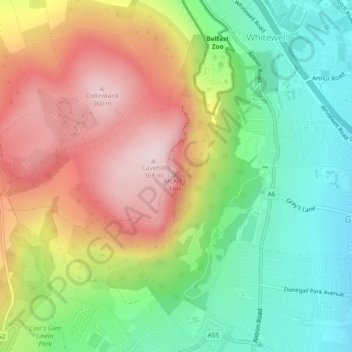
Name: Topografische Karte Cavehill, Höhe, Relief.
Durchschnittliche Höhe: 188 m
Minimale Höhe: 24 m
Maximale Höhe: 364 m
Andere topografische Karten
Klicken Sie auf eine Karte, um ihre Topografie, ihre Höhe und ihr Relief anzuzeigen.
Ballygomartin
United Kingdom > Northern Ireland > County Antrim > Belfast
Ballygomartin, Ligoniel, Belfast, County Antrim, Northern Ireland, United Kingdom
Durchschnittliche Höhe: 258 m
Botanic Gardens
United Kingdom > Northern Ireland > County Antrim > Belfast
Botanic Gardens, Queen's Quarter, Belfast, County Antrim, Northern Ireland, United Kingdom
Durchschnittliche Höhe: 15 m
McArt's Fort
United Kingdom > Northern Ireland > County Antrim > Belfast
McArt's Fort, Ben Madigan Heights, Whitewell, Belfast, County Antrim, Northern Ireland, BT36 7RW, United Kingdom
Durchschnittliche Höhe: 165 m
Edenderry
United Kingdom > Northern Ireland > County Antrim > Belfast
Edenderry, Woodvale, Belfast, County Antrim, Northern Ireland, United Kingdom
Durchschnittliche Höhe: 50 m