
Topografische Karte Cranleigh
Interaktive Karte
Klicken Sie auf die Karte, um die Höhe anzuzeigen.
Cranleigh
Elevations range from a maximum of 240 m AOD (mean high water level) at the car park on Reynolds Hill in Winterfold Heath (a woodland in the north) to 41 m on the watercourse and the disused Wey and Arun Canal as they leave both the parish in the northwest extreme at the end of East Whipley Lane. The village centre lies at generally 50–70 m above AOD.
Über diese Karte
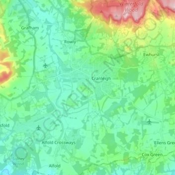
Name: Topografische Karte Cranleigh, Höhe, Relief.
Ort: Cranleigh, Waverley, Surrey, England, United Kingdom (51.09161 -0.53429 51.17952 -0.44967)
Durchschnittliche Höhe: 78 m
Minimale Höhe: 24 m
Maximale Höhe: 257 m
Andere topografische Karten
Klicken Sie auf eine Karte, um ihre Topografie, ihre Höhe und ihr Relief anzuzeigen.
Frensham Great Pond
United Kingdom > England > Surrey > Waverley > Frensham
Durchschnittliche Höhe: 72 m
Rodborough Common
United Kingdom > England > Surrey > Waverley > Cramhurst
Durchschnittliche Höhe: 62 m
Rodborough Common
United Kingdom > England > Surrey > Waverley > Cramhurst
Durchschnittliche Höhe: 62 m
Hankley Common
United Kingdom > England > Surrey > Waverley > Thursley > Truxford
Durchschnittliche Höhe: 70 m
Floodplain (seasonal)
United Kingdom > England > Surrey > Waverley > Farnham > Wrecclesham
Durchschnittliche Höhe: 94 m
Lakers Green
United Kingdom > England > Surrey > Waverley > Alfold Crossways
Durchschnittliche Höhe: 55 m
Winkworth Arboretum
United Kingdom > England > Surrey > Waverley > Hascombe
Durchschnittliche Höhe: 111 m