
Topografische Karte Etosha-Nationalpark
Interaktive Karte
Klicken Sie auf die Karte, um die Höhe anzuzeigen.
Über diese Karte
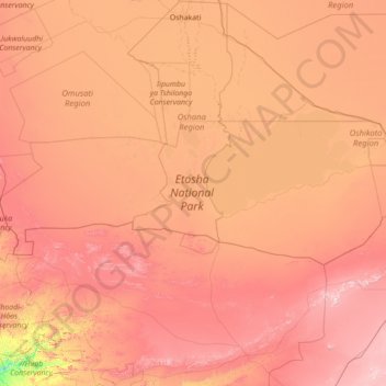
Name: Topografische Karte Etosha-Nationalpark, Höhe, Relief.
Ort: Etosha-Nationalpark, Namibia (-19.48696 14.35317 -18.50075 17.15128)
Durchschnittliche Höhe: 1.169 m
Minimale Höhe: 609 m
Maximale Höhe: 1.792 m
Andere topografische Karten
Klicken Sie auf eine Karte, um ihre Topografie, ihre Höhe und ihr Relief anzuzeigen.
Otjiwarongo
Otjiwarongo, Otjozondjupa, 12001, Namibia
Durchschnittliche Höhe: 1.471 m
Hochfeld
Namibia > Otjozondjupa > Hochfeld
Hochfeld, Otjozondjupa, Namibia
Durchschnittliche Höhe: 1.559 m
Keetmanshoop
Namibia > ǁKaras > Keetmanshoop
Keetmanshoop, ǁKaras, Namibia
Durchschnittliche Höhe: 990 m
Wilhelmstal
Namibia > Erongo > Wilhelmstal
Wilhelmstal, Erongo, Namibia
Durchschnittliche Höhe: 1.348 m
NamibRand Nature Reserve
NamibRand Nature Reserve, Hardap, Namibia
Durchschnittliche Höhe: 1.160 m