
Topografische Karte Lowdham CP
Interaktive Karte
Klicken Sie auf die Karte, um die Höhe anzuzeigen.
Über diese Karte
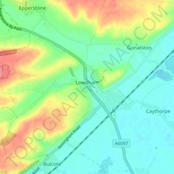
Name: Topografische Karte Lowdham CP, Höhe, Relief.
Durchschnittliche Höhe: 38 m
Minimale Höhe: 15 m
Maximale Höhe: 84 m
Andere topografische Karten
Klicken Sie auf eine Karte, um ihre Topografie, ihre Höhe und ihr Relief anzuzeigen.
Newark on Trent
United Kingdom > England > Nottinghamshire > Newark and Sherwood
Durchschnittliche Höhe: 18 m
Goverton
United Kingdom > England > Nottinghamshire > Newark and Sherwood > Bleasby
Durchschnittliche Höhe: 34 m
Ollerton
United Kingdom > England > Nottinghamshire > Newark and Sherwood
Durchschnittliche Höhe: 59 m
Clipstone
United Kingdom > England > Nottinghamshire > Newark and Sherwood
Durchschnittliche Höhe: 94 m
Sherwood Forest NNR
United Kingdom > England > Nottinghamshire > Newark and Sherwood > Ollerton > Edwinstowe CP
Durchschnittliche Höhe: 71 m
Blidworth Bottoms
United Kingdom > England > Nottinghamshire > Newark and Sherwood > Blidworth CP
Durchschnittliche Höhe: 107 m
Coddington
United Kingdom > England > Nottinghamshire > Newark and Sherwood
Durchschnittliche Höhe: 23 m
Farndon
United Kingdom > England > Nottinghamshire > Newark and Sherwood > Farndon
Durchschnittliche Höhe: 14 m
Halloughton
United Kingdom > England > Nottinghamshire > Newark and Sherwood
Durchschnittliche Höhe: 61 m
Syerston
United Kingdom > England > Nottinghamshire > Newark and Sherwood
Durchschnittliche Höhe: 34 m
Balderton
United Kingdom > England > Nottinghamshire > Newark and Sherwood
Durchschnittliche Höhe: 19 m
Kings Clipstone
United Kingdom > England > Nottinghamshire > Newark and Sherwood
Durchschnittliche Höhe: 81 m
Danethorpe Hill
United Kingdom > England > Nottinghamshire > Newark and Sherwood
Durchschnittliche Höhe: 22 m