
Topografische Karte Halloughton
Interaktive Karte
Klicken Sie auf die Karte, um die Höhe anzuzeigen.
Über diese Karte
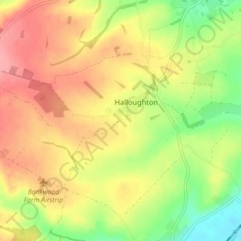
Name: Topografische Karte Halloughton, Höhe, Relief.
Durchschnittliche Höhe: 64 m
Minimale Höhe: 15 m
Maximale Höhe: 104 m
Andere topografische Karten
Klicken Sie auf eine Karte, um ihre Topografie, ihre Höhe und ihr Relief anzuzeigen.
Syerston
United Kingdom > England > Newark and Sherwood > Nottinghamshire
Syerston, Newark and Sherwood, Nottinghamshire, East Midlands, England, United Kingdom
Durchschnittliche Höhe: 40 m
Fiskerton cum Morton
United Kingdom > England > Newark and Sherwood > Nottinghamshire
Fiskerton cum Morton, Newark and Sherwood, Nottinghamshire, East Midlands, England, United Kingdom
Durchschnittliche Höhe: 21 m
Ollerton and Boughton CP
United Kingdom > England > Newark and Sherwood > Nottinghamshire
Ollerton and Boughton CP, Newark and Sherwood, Nottinghamshire, East Midlands, England, United Kingdom
Durchschnittliche Höhe: 52 m
River Greet
United Kingdom > England > Newark and Sherwood > Nottinghamshire
River Greet, Newark and Sherwood, Nottinghamshire, East Midlands, England, NG25 0TT, United Kingdom
Durchschnittliche Höhe: 15 m
Balderton
United Kingdom > England > Newark and Sherwood > Nottinghamshire
Balderton, Newark and Sherwood, Nottinghamshire, East Midlands, England, United Kingdom
Durchschnittliche Höhe: 20 m