
Topografische Karte Broken Bow
Interaktive Karte
Klicken Sie auf die Karte, um die Höhe anzuzeigen.
Über diese Karte
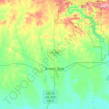
Name: Topografische Karte Broken Bow, Höhe, Relief.
Ort: Broken Bow, McCurtain County, Oklahoma, United States (33.95544 -94.77445 34.15653 -94.70551)
Durchschnittliche Höhe: 155 m
Minimale Höhe: 95 m
Maximale Höhe: 304 m
The city sits at the foothills of the Kiamichi Mountains, a subrange of the Ouachita Mountains. the Kiamichi Mountains sit within Le Flore, Pushmataha, and McCurtain counties near the towns of Poteau and Albion. The Kiamichi peaks line up south of the Kiamichi River and reach 2,500 feet (760 m) in elevation. The range is the namesake of Kiamichi Country, the official tourism designation for southeastern Oklahoma.
Andere topografische Karten
Klicken Sie auf eine Karte, um ihre Topografie, ihre Höhe und ihr Relief anzuzeigen.
Hochatown
United States > Oklahoma > McCurtain County
Hochatown, McCurtain County, Oklahoma, United States
Durchschnittliche Höhe: 220 m
Hochatown
United States > Oklahoma > McCurtain County
Hochatown, McCurtain County, Oklahoma, United States
Durchschnittliche Höhe: 218 m
Beavers Bend State Park
United States > Oklahoma > McCurtain County
Beavers Bend State Park, McCurtain County, Oklahoma, United States
Durchschnittliche Höhe: 178 m
Watson
United States > Oklahoma > McCurtain County
Watson, McCurtain County, Oklahoma, 74963, United States
Durchschnittliche Höhe: 268 m
Garvin
United States > Oklahoma > McCurtain County > Garvin
Garvin, McCurtain County, Oklahoma, United States
Durchschnittliche Höhe: 144 m
Eagletown
United States > Oklahoma > McCurtain County > Eagletown
Eagletown, McCurtain County, Oklahoma, 74734, United States
Durchschnittliche Höhe: 120 m
Pickens
United States > Oklahoma > McCurtain County > Pickens
Pickens, McCurtain County, Oklahoma, United States
Durchschnittliche Höhe: 261 m
Broken Bow Lake
United States > Oklahoma > McCurtain County
Broken Bow Lake, McCurtain County, Oklahoma, United States
Durchschnittliche Höhe: 158 m
Idabel
United States > Oklahoma > McCurtain County
Idabel, McCurtain County, Oklahoma, United States
Durchschnittliche Höhe: 132 m