
Topografische Karte Sydney Water Supply Canal
Interaktive Karte
Klicken Sie auf die Karte, um die Höhe anzuzeigen.
Über diese Karte
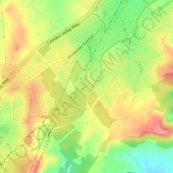
Name: Topografische Karte Sydney Water Supply Canal, Höhe, Relief.
Durchschnittliche Höhe: 102 m
Minimale Höhe: 49 m
Maximale Höhe: 140 m
Andere topografische Karten
Klicken Sie auf eine Karte, um ihre Topografie, ihre Höhe und ihr Relief anzuzeigen.
Penrith
Australia > New South Wales > Sydney > Penrith
Penrith is a city in New South Wales, Australia, located in Greater Western Sydney, 55 kilometres (31 mi) west of the Sydney central business district on the banks of the Nepean River, on the outskirts of the Cumberland Plain. Its elevation is 32 metres (105 ft).
Durchschnittliche Höhe: 34 m
Wentworth Falls
Australia > New South Wales > Sydney
Wentworth Falls (postcode: 2782) is a town in the Blue Mountains region of New South Wales, situated approximately 100 kilometres (62 mi) west of the Sydney central business district, and about 8 kilometres (5.0 mi) east of Katoomba, Australia on the Great Western Highway, with a Wentworth Falls railway…
Durchschnittliche Höhe: 708 m
Bullaburra
Australia > New South Wales > Sydney
By 1986, Bruce's Walk had come to the attention of two other walkers, Jim Smith and Wilf Hilder, who organised a group of volunteers to clear the track between Bullaburra and Wentworth Falls. In the process, they found many artefacts and features, including signs, shelter caves, seats and picnic tables. This…
Durchschnittliche Höhe: 712 m
East Kurrajong
Australia > New South Wales > Sydney
The geology of the ridge is sandstone, capped intermittently with shale. Elevation ranges from a little above sea level to approximately 140 m. The vegetation type is Cumberland Plain dry sclerophyll forest and eucalypt woodland.
Durchschnittliche Höhe: 80 m
Penrith
Australia > New South Wales > Sydney > Penrith
Penrith is a city in New South Wales, Australia, located in Greater Western Sydney, 55 kilometres (31 mi) west of the Sydney central business district on the banks of the Nepean River, on the outskirts of the Cumberland Plain. Its elevation is 32 metres (105 ft).
Durchschnittliche Höhe: 34 m