
Spenden
Rüsten Sie sich für Ihr nächstes Abenteuer:
Als Amazon-Partner erhält diese Website eine Provision für qualifizierte Käufe, ohne zusätzliche Kosten für Sie.
Topografische Karte Redwood Park
Klicken Sie auf die Karte, um die Höhe anzuzeigen.
Spenden
Rüsten Sie sich für Ihr nächstes Abenteuer:
Als Amazon-Partner erhält diese Website eine Provision für qualifizierte Käufe, ohne zusätzliche Kosten für Sie.
Über diese Karte
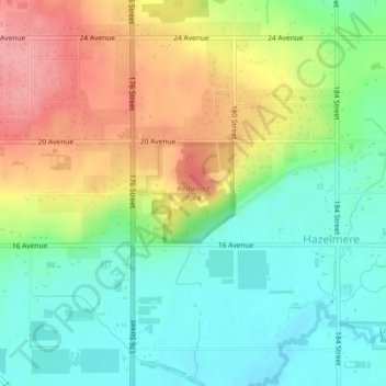
Name: Topografische Karte Redwood Park, Höhe, Relief.
Durchschnittliche Höhe: 49 m
Minimale Höhe: 6 m
Maximale Höhe: 110 m
Spenden
Rüsten Sie sich für Ihr nächstes Abenteuer:
Als Amazon-Partner erhält diese Website eine Provision für qualifizierte Käufe, ohne zusätzliche Kosten für Sie.
Andere topografische Karten
Klicken Sie auf eine Karte, um ihre Topografie, ihre Höhe und ihr Relief anzuzeigen.
Vancouver
Canada > British Columbia > Metro Vancouver Regional District
Vancouver, British Columbia, is situated on the Burrard Peninsula, bordered by Burrard Inlet to the north and the Fraser River to the south. The city's topography is a blend of flat and hilly terrains, with elevations ranging from sea level to approximately 152 meters (500 feet) above sea level. The North…
Durchschnittliche Höhe: 34 m
Coquitlam
Canada > British Columbia > Metro Vancouver Regional District
Like much of Metro Vancouver, Coquitlam has an oceanic climate (Köppen climate type Cfb), experiencing mild temperatures and high precipitation; warm, dry summers and cool, wet winters. However, compared to most other cities in the area, precipitation is especially heavy in Coquitlam due to its proximity to…
Durchschnittliche Höhe: 190 m
Burnaby
Canada > British Columbia > Metro Vancouver Regional District > Burnaby
Burnaby occupies 98.60 square kilometres (38.07 sq mi) and is located at the geographic centre of the Metro Vancouver area and home to the Metro Vancouver regional government in Metrotown. Situated between the city of Vancouver on the west and Port Moody, Coquitlam, and New Westminster on the east, Burnaby is…
Durchschnittliche Höhe: 144 m
Burnaby
Canada > British Columbia > Metro Vancouver Regional District
Burnaby occupies 98.6 square kilometres (38.1 sq mi) and is located at the geographic centre of the Metro Vancouver Regional District. The regional district's government is located in Burnaby's Metrotown area. Situated between the city of Vancouver on the west and Port Moody, Coquitlam, and New Westminster on…
Durchschnittliche Höhe: 59 m
Spenden
Rüsten Sie sich für Ihr nächstes Abenteuer:
Als Amazon-Partner erhält diese Website eine Provision für qualifizierte Käufe, ohne zusätzliche Kosten für Sie.
Township of Langley
Canada > British Columbia > Metro Vancouver Regional District
Durchschnittliche Höhe: 47 m
University Endowment Lands
Canada > British Columbia > Metro Vancouver Regional District
Snowfalls are also more common than many parts of the City of Vancouver because of the area's higher altitude and the lack of an urban heat island due to less terrestrial development.
Durchschnittliche Höhe: 58 m
Spenden
Rüsten Sie sich für Ihr nächstes Abenteuer:
Als Amazon-Partner erhält diese Website eine Provision für qualifizierte Käufe, ohne zusätzliche Kosten für Sie.
Coquitlam
Canada > British Columbia > Metro Vancouver Regional District > Coquitlam
Southwest Coquitlam comprises the original core of the city, with Maillardville and Fraser River industrial sector giving way to the large residential areas of Austin Heights, colloquially referred to as "The Bump" due to its high and flat plateau topography. These older residences, with larger property…
Durchschnittliche Höhe: 230 m
Tsawwassen
Canada > British Columbia > Metro Vancouver Regional District > Delta
Durchschnittliche Höhe: 12 m
West Vancouver
Canada > British Columbia > Metro Vancouver Regional District
Durchschnittliche Höhe: 384 m
Spenden
Rüsten Sie sich für Ihr nächstes Abenteuer:
Als Amazon-Partner erhält diese Website eine Provision für qualifizierte Käufe, ohne zusätzliche Kosten für Sie.
Langley Township
Canada > British Columbia > Metro Vancouver Regional District > Township of Langley > Langley Township
Durchschnittliche Höhe: 37 m
Surrey
Canada > British Columbia > Metro Vancouver Regional District > Surrey
Durchschnittliche Höhe: 65 m
Aldergrove
Canada > British Columbia > Metro Vancouver Regional District > Township of Langley
Durchschnittliche Höhe: 107 m
Port Coquitlam
Canada > British Columbia > Metro Vancouver Regional District
Durchschnittliche Höhe: 29 m
Spenden
Rüsten Sie sich für Ihr nächstes Abenteuer:
Als Amazon-Partner erhält diese Website eine Provision für qualifizierte Käufe, ohne zusätzliche Kosten für Sie.
Vancouver
Canada > British Columbia > Metro Vancouver Regional District
Vancouver, British Columbia, is situated on the Burrard Peninsula, bordered by Burrard Inlet to the north and the Fraser River to the south. The city's topography is a blend of flat and hilly terrains, with elevations ranging from sea level to approximately 152 meters (500 feet) above sea level. The North…
Durchschnittliche Höhe: 34 m
Burnaby Mountain
Canada > British Columbia > Metro Vancouver Regional District > Burnaby
Due to its relatively high elevation, snow will often fall on the higher levels of Burnaby Mountain while rain falls in the surrounding cities. Tobogganing is a popular pastime at Centennial Park on winter days with snow.
Durchschnittliche Höhe: 167 m
Port Moody
Canada > British Columbia > Metro Vancouver Regional District
Durchschnittliche Höhe: 189 m
North Shore Mountains
Canada > British Columbia > Metro Vancouver Regional District
Durchschnittliche Höhe: 634 m
Spenden
Rüsten Sie sich für Ihr nächstes Abenteuer:
Als Amazon-Partner erhält diese Website eine Provision für qualifizierte Käufe, ohne zusätzliche Kosten für Sie.
New Westminster
Canada > British Columbia > Metro Vancouver Regional District
Durchschnittliche Höhe: 44 m
Grouse Mountain
Canada > British Columbia > Metro Vancouver Regional District
Grouse Mountain is one of the North Shore Mountains of the Pacific Ranges in the District Municipality of North Vancouver, British Columbia, Canada. With a maximum elevation of over 1,200 m (4,100 feet) at its peak, the mountain is the site of an alpine ski area, Grouse Mountain Resort, which overlooks Greater…
Durchschnittliche Höhe: 968 m
Maple Ridge
Canada > British Columbia > Metro Vancouver Regional District
Durchschnittliche Höhe: 185 m
Spenden
Rüsten Sie sich für Ihr nächstes Abenteuer:
Als Amazon-Partner erhält diese Website eine Provision für qualifizierte Käufe, ohne zusätzliche Kosten für Sie.
Pitt Meadows
Canada > British Columbia > Metro Vancouver Regional District
Durchschnittliche Höhe: 121 m
Little Mountain
Canada > British Columbia > Metro Vancouver Regional District > Vancouver
Little Mountain, elevation 125 m (410 ft), is a mountain in the central part of the city of Vancouver, British Columbia, Canada. The mountain is home to Queen Elizabeth Park, which sits at the top of the mountain, and Nat Bailey Stadium, which is located near the base. The mountain lends its name to the Riley…
Durchschnittliche Höhe: 81 m
Ladner
Canada > British Columbia > Metro Vancouver Regional District > Delta
Durchschnittliche Höhe: 2 m
Spenden
Rüsten Sie sich für Ihr nächstes Abenteuer:
Als Amazon-Partner erhält diese Website eine Provision für qualifizierte Käufe, ohne zusätzliche Kosten für Sie.
Vancouver
Canada > British Columbia > Metro Vancouver Regional District
Vancouver's growing season averages 237 days, from March 18 until November 10. Vancouver's 1981–2010 USDA Plant Hardiness Zone ranges from 8a to 9a depending on elevation and proximity to water.
Durchschnittliche Höhe: 34 m
Cloverdale
Canada > British Columbia > Metro Vancouver Regional District > Surrey
Durchschnittliche Höhe: 24 m
Bowen Island
Canada > British Columbia > Metro Vancouver Regional District > Bowen Island Municipality
Durchschnittliche Höhe: 106 m
Spenden
Rüsten Sie sich für Ihr nächstes Abenteuer:
Als Amazon-Partner erhält diese Website eine Provision für qualifizierte Käufe, ohne zusätzliche Kosten für Sie.
City of Langley
Canada > British Columbia > Metro Vancouver Regional District
Durchschnittliche Höhe: 19 m
Port Coquitlam
Canada > British Columbia > Metro Vancouver Regional District
Durchschnittliche Höhe: 29 m
Vancouver
Canada > British Columbia > Metro Vancouver Regional District
Vancouver, British Columbia, is situated on the Burrard Peninsula, bordered by Burrard Inlet to the north and the Fraser River to the south. The city's topography is a blend of flat and hilly terrains, with elevations ranging from sea level to approximately 152 meters (500 feet) above sea level. The North…
Durchschnittliche Höhe: 34 m
District of North Vancouver
Canada > British Columbia > Metro Vancouver Regional District
Durchschnittliche Höhe: 358 m
Spenden
Rüsten Sie sich für Ihr nächstes Abenteuer:
Als Amazon-Partner erhält diese Website eine Provision für qualifizierte Käufe, ohne zusätzliche Kosten für Sie.
Tsawwassen
Canada > British Columbia > Metro Vancouver Regional District > Delta
Durchschnittliche Höhe: 12 m
Cypress Pond
Canada > British Columbia > Metro Vancouver Regional District > Vancouver
Durchschnittliche Höhe: 86 m
Spenden
Rüsten Sie sich für Ihr nächstes Abenteuer:
Als Amazon-Partner erhält diese Website eine Provision für qualifizierte Käufe, ohne zusätzliche Kosten für Sie.
District of North Vancouver
Canada > British Columbia > Metro Vancouver Regional District
Durchschnittliche Höhe: 358 m
Burnaby
Canada > British Columbia > Metro Vancouver Regional District
Burnaby occupies 96.6 square kilometres (37.3 sq mi) and is located at the geographic centre of the Metro Vancouver Regional District. The city has four areas of urban density known as "town centres": Lougheed, Edmonds, Metrotown, and Brentwood. The city's governmental and cultural precincts are located in…
Durchschnittliche Höhe: 59 m
Delta
Canada > British Columbia > Metro Vancouver Regional District > Delta
Durchschnittliche Höhe: 13 m
New Westminster
Canada > British Columbia > Metro Vancouver Regional District
Durchschnittliche Höhe: 44 m
Spenden
Rüsten Sie sich für Ihr nächstes Abenteuer:
Als Amazon-Partner erhält diese Website eine Provision für qualifizierte Käufe, ohne zusätzliche Kosten für Sie.
Aldergrove
Canada > British Columbia > Metro Vancouver Regional District > Township of Langley
Durchschnittliche Höhe: 107 m
Township of Langley
Canada > British Columbia > Metro Vancouver Regional District
Durchschnittliche Höhe: 47 m
Bowen Island Municipality
Canada > British Columbia > Metro Vancouver Regional District
Durchschnittliche Höhe: 95 m
Sea Island
Canada > British Columbia > Metro Vancouver Regional District > Richmond
Durchschnittliche Höhe: 6 m
Spenden
Rüsten Sie sich für Ihr nächstes Abenteuer:
Als Amazon-Partner erhält diese Website eine Provision für qualifizierte Käufe, ohne zusätzliche Kosten für Sie.
Burns Bog Ecological Conservancy Area
Canada > British Columbia > Metro Vancouver Regional District > Delta
Durchschnittliche Höhe: 5 m
New Westminster
Canada > British Columbia > Metro Vancouver Regional District
Durchschnittliche Höhe: 87 m
Port Moody
Canada > British Columbia > Metro Vancouver Regional District
Durchschnittliche Höhe: 189 m
Spenden
Rüsten Sie sich für Ihr nächstes Abenteuer:
Als Amazon-Partner erhält diese Website eine Provision für qualifizierte Käufe, ohne zusätzliche Kosten für Sie.
City of Langley
Canada > British Columbia > Metro Vancouver Regional District
Durchschnittliche Höhe: 19 m
Maple Ridge
Canada > British Columbia > Metro Vancouver Regional District
Durchschnittliche Höhe: 185 m
Port Moody
Canada > British Columbia > Metro Vancouver Regional District
Durchschnittliche Höhe: 189 m
North Vancouver
Canada > British Columbia > Metro Vancouver Regional District
Durchschnittliche Höhe: 54 m
Spenden
Rüsten Sie sich für Ihr nächstes Abenteuer:
Als Amazon-Partner erhält diese Website eine Provision für qualifizierte Käufe, ohne zusätzliche Kosten für Sie.
Ladner
Canada > British Columbia > Metro Vancouver Regional District > Delta
Durchschnittliche Höhe: 2 m
Golden Ears
Canada > British Columbia > Metro Vancouver Regional District > Maple Ridge
Durchschnittliche Höhe: 189 m
Crystal Falls
Canada > British Columbia > Metro Vancouver Regional District > Coquitlam
Durchschnittliche Höhe: 221 m
Spenden
Rüsten Sie sich für Ihr nächstes Abenteuer:
Als Amazon-Partner erhält diese Website eine Provision für qualifizierte Käufe, ohne zusätzliche Kosten für Sie.
Queens Park
Canada > British Columbia > Metro Vancouver Regional District > New Westminster
Durchschnittliche Höhe: 57 m
Sunset
Canada > British Columbia > Metro Vancouver Regional District > Vancouver
Durchschnittliche Höhe: 53 m
Government Road
Canada > British Columbia > Metro Vancouver Regional District > Burnaby
Durchschnittliche Höhe: 45 m
Burnaby
Canada > British Columbia > Metro Vancouver Regional District
Burnaby occupies 96.6 square kilometres (37.3 sq mi) and is located at the geographic centre of the Metro Vancouver Regional District. The city has four areas of urban density known as "town centres": Lougheed, Edmonds, Metrotown, and Brentwood. The city's governmental and cultural precincts are located in…
Durchschnittliche Höhe: 59 m
Spenden
Rüsten Sie sich für Ihr nächstes Abenteuer:
Als Amazon-Partner erhält diese Website eine Provision für qualifizierte Käufe, ohne zusätzliche Kosten für Sie.
Maple Ridge
Canada > British Columbia > Metro Vancouver Regional District
Durchschnittliche Höhe: 185 m
Mount Pleasant
Canada > British Columbia > Metro Vancouver Regional District > Vancouver
Durchschnittliche Höhe: 28 m
Burnaby
Canada > British Columbia > Metro Vancouver Regional District
Burnaby occupies 96.6 square kilometres (37.3 sq mi) and is located at the geographic centre of the Metro Vancouver Regional District. The city has four areas of urban density known as "town centres": Lougheed, Edmonds, Metrotown, and Brentwood. The city's governmental and cultural precincts are located in…
Durchschnittliche Höhe: 59 m
Spenden
Rüsten Sie sich für Ihr nächstes Abenteuer:
Als Amazon-Partner erhält diese Website eine Provision für qualifizierte Käufe, ohne zusätzliche Kosten für Sie.
Queensborough
Canada > British Columbia > Metro Vancouver Regional District > New Westminster
Durchschnittliche Höhe: 5 m
Coquitlam
Canada > British Columbia > Metro Vancouver Regional District
Like much of Metro Vancouver, Coquitlam has an oceanic climate (Köppen climate type Cfb), experiencing mild temperatures and high precipitation; warm, dry summers and cool, wet winters. However, compared to most other cities in the area, precipitation is especially heavy in Coquitlam due to its proximity to…
Durchschnittliche Höhe: 190 m
Kensington-Cedar Cottage
Canada > British Columbia > Metro Vancouver Regional District > Vancouver
Durchschnittliche Höhe: 64 m
Grandview-Woodland
Canada > British Columbia > Metro Vancouver Regional District > Vancouver
Durchschnittliche Höhe: 28 m
Spenden
Rüsten Sie sich für Ihr nächstes Abenteuer:
Als Amazon-Partner erhält diese Website eine Provision für qualifizierte Käufe, ohne zusätzliche Kosten für Sie.
Renfrew-Collingwood
Canada > British Columbia > Metro Vancouver Regional District > Vancouver
Durchschnittliche Höhe: 72 m
Lighthouse Park
Canada > British Columbia > Metro Vancouver Regional District > West Vancouver
The sword fern (Polystichum munitum), one of the most abundant ferns in North America, can be found from Alaska to California and is named for its small upward-pointing lobe that resembles a sword hilt. This fern prefers to grow in moist, coniferous low elevation environments but can survive dry periods.…
Durchschnittliche Höhe: 22 m
North Peak
Canada > British Columbia > Metro Vancouver Regional District > Bowen Island Municipality
Durchschnittliche Höhe: 331 m
Queensborough
Canada > British Columbia > Metro Vancouver Regional District > New Westminster
Durchschnittliche Höhe: 5 m
Spenden
Rüsten Sie sich für Ihr nächstes Abenteuer:
Als Amazon-Partner erhält diese Website eine Provision für qualifizierte Käufe, ohne zusätzliche Kosten für Sie.
Vancouver East
Canada > British Columbia > Metro Vancouver Regional District > Vancouver
Durchschnittliche Höhe: 25 m
West Vancouver
Canada > British Columbia > Metro Vancouver Regional District
Durchschnittliche Höhe: 384 m
Burnaby
Canada > British Columbia > Metro Vancouver Regional District
Burnaby occupies 96.6 square kilometres (37.3 sq mi) and is located at the geographic centre of the Metro Vancouver Regional District. The city has four areas of urban density known as "town centres": Lougheed, Edmonds, Metrotown, and Brentwood. The city's governmental and cultural precincts are located in…
Durchschnittliche Höhe: 59 m
Spenden
Rüsten Sie sich für Ihr nächstes Abenteuer:
Als Amazon-Partner erhält diese Website eine Provision für qualifizierte Käufe, ohne zusätzliche Kosten für Sie.
Vancouver
Canada > British Columbia > Metro Vancouver Regional District
Vancouver's growing season averages 237 days, from March 18 until November 10. Vancouver's 1981–2010 USDA Plant Hardiness Zone ranges from 8a to 9a depending on elevation and proximity to water.
Durchschnittliche Höhe: 34 m
Kitsilano
Canada > British Columbia > Metro Vancouver Regional District > Vancouver
Durchschnittliche Höhe: 24 m
University of British Columbia
Canada > British Columbia > Metro Vancouver Regional District > Electoral Area A
Durchschnittliche Höhe: 64 m
Fairview
Canada > British Columbia > Metro Vancouver Regional District > Vancouver
Durchschnittliche Höhe: 31 m
Spenden
Rüsten Sie sich für Ihr nächstes Abenteuer:
Als Amazon-Partner erhält diese Website eine Provision für qualifizierte Käufe, ohne zusätzliche Kosten für Sie.
West Cambie
Canada > British Columbia > Metro Vancouver Regional District > Richmond
Durchschnittliche Höhe: 3 m
Lynn Canyon Park
Canada > British Columbia > Metro Vancouver Regional District
The ecology of Lynn Valley is quite vast as it expands to the entire North Vancouver area. There are several species of animals that can be found both within the Lynn Canyon Park as well as other surrounding regions such as Horseshoe Bay and the local mountains. Just like the wildlife in the area, the plant…
Durchschnittliche Höhe: 184 m
Vancouver
Canada > British Columbia > Metro Vancouver Regional District
Vancouver's growing season averages 237 days, from March 18 until November 10. Vancouver's 1981–2010 USDA Plant Hardiness Zone ranges from 8a to 9a depending on elevation and proximity to water.
Durchschnittliche Höhe: 34 m
South Surrey
Canada > British Columbia > Metro Vancouver Regional District > Surrey
Durchschnittliche Höhe: 28 m
Spenden
Rüsten Sie sich für Ihr nächstes Abenteuer:
Als Amazon-Partner erhält diese Website eine Provision für qualifizierte Käufe, ohne zusätzliche Kosten für Sie.
New Westminster
Canada > British Columbia > Metro Vancouver Regional District
Durchschnittliche Höhe: 87 m
Kitsilano
Canada > British Columbia > Metro Vancouver Regional District > Vancouver
Durchschnittliche Höhe: 24 m
Dunbar-Southlands
Canada > British Columbia > Metro Vancouver Regional District > Vancouver
Durchschnittliche Höhe: 43 m
Spenden
Rüsten Sie sich für Ihr nächstes Abenteuer:
Als Amazon-Partner erhält diese Website eine Provision für qualifizierte Käufe, ohne zusätzliche Kosten für Sie.
Black Mountain (North Summit)
Canada > British Columbia > Metro Vancouver Regional District > West Vancouver
Durchschnittliche Höhe: 931 m
North Vancouver
Canada > British Columbia > Metro Vancouver Regional District
Durchschnittliche Höhe: 54 m
Steveston
Canada > British Columbia > Metro Vancouver Regional District > Richmond
Durchschnittliche Höhe: 2 m
Spenden
Rüsten Sie sich für Ihr nächstes Abenteuer:
Als Amazon-Partner erhält diese Website eine Provision für qualifizierte Käufe, ohne zusätzliche Kosten für Sie.
North Delta
Canada > British Columbia > Metro Vancouver Regional District > Delta
Durchschnittliche Höhe: 48 m
Township of Langley
Canada > British Columbia > Metro Vancouver Regional District
Durchschnittliche Höhe: 47 m
West Vancouver
Canada > British Columbia > Metro Vancouver Regional District
Durchschnittliche Höhe: 384 m
Spenden
Rüsten Sie sich für Ihr nächstes Abenteuer:
Als Amazon-Partner erhält diese Website eine Provision für qualifizierte Käufe, ohne zusätzliche Kosten für Sie.