
Topografische Karte Paravur
Interaktive Karte
Klicken Sie auf die Karte, um die Höhe anzuzeigen.
Über diese Karte
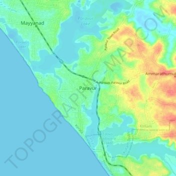
Name: Topografische Karte Paravur, Höhe, Relief.
Ort: Paravur, Kollam, Kollam District, Kerala, 691301, India (8.76989 76.63153 8.84989 76.71153)
Durchschnittliche Höhe: 14 m
Minimale Höhe: -5 m
Maximale Höhe: 60 m
Paravur is located at 8.78 N 76 E.[4] It has an average elevation of 10 metres (32 feet). Paravur, 21 kilometers from the Kollam, is a narrow skirt of land stretching in between the backwaters and the sea. There is an elevation of 6 metres above sea level, extending to 16 metres on the inland. Ithikkara river is flowing through paravur. Nedungolam in paravur is now famous for mangrove forest.[citation needed]
Andere topografische Karten
Klicken Sie auf eine Karte, um ihre Topografie, ihre Höhe und ihr Relief anzuzeigen.
Kizhakkekallada
Kizhakkekallada, Kollam, Kollam District, Kerala, 691502, India
Durchschnittliche Höhe: 10 m
Sakthikulangara
Sakthikulangara, Kollam, Kerala, 691581, India
Durchschnittliche Höhe: 4 m
Uliyakovil
India > Kerala > Kollam > Kollam
Uliyakovil, Kollam, Kerala, 691001, India
Durchschnittliche Höhe: 10 m