
Topografische Karte Upputhara
Interaktive Karte
Klicken Sie auf die Karte, um die Höhe anzuzeigen.
Über diese Karte
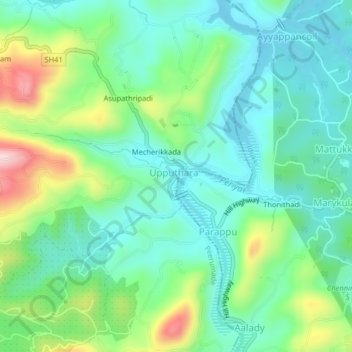
Name: Topografische Karte Upputhara, Höhe, Relief.
Ort: Upputhara, Idukki, Kerala, 685507, India (9.67952 77.00120 9.71952 77.04120)
Durchschnittliche Höhe: 801 m
Minimale Höhe: 718 m
Maximale Höhe: 1.010 m
Upputhara is a village in Idukki district in the Indian state of Kerala. Upputhara panchayat, belonging to the block panchayat of Kattappana, is situated in the southern part of Idukki district in the Peermade taluk. The panchayat is bordered by the Periyar River in the east, the Meenmutti Lake in the west, the Chinnar River and the Karintharuvi River in the south and the Kakkathode protected forests in the north. Upputhara is located in the Western Ghats region of Kerala that borders on the neighbouring State of Tamil Nadu. Geographically, Upputhara is divided into six types of land forms; mountains, highly steep land, moderately steep land, valleys, marshy lands and rocky lands. Of these six land forms, about 40 percent of the total area is classified under valleys. Next in importance are marshy lands, slightly steep land, mountains, very steep land and rocky lands, in that order. Valleys and marshy lands together accounted for 62 percent of the area. Owing to the presence of large tracts of land with undulating topography, agriculture in Upputhara is faced with several challenges such as soil erosion.