
Topografische Karte Rupa
Interaktive Karte
Klicken Sie auf die Karte, um die Höhe anzuzeigen.
Über diese Karte
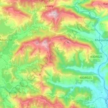
Name: Topografische Karte Rupa, Höhe, Relief.
Ort: Rupa, कास्की, Provinz Gandaki, Nepal (28.09439 84.10302 28.19544 84.22979)
Durchschnittliche Höhe: 769 m
Minimale Höhe: 382 m
Maximale Höhe: 1.398 m
Andere topografische Karten
Klicken Sie auf eine Karte, um ihre Topografie, ihre Höhe und ihr Relief anzuzeigen.
Panchase Bhanjyang
Panchase Bhanjyang, Pokhara, कास्की, Provinz Gandaki, Nepal
Durchschnittliche Höhe: 1.851 m
Machhapuchchhre
Machhapuchchhre, कास्की, Provinz Gandaki, Nepal
Durchschnittliche Höhe: 3.545 m