
Topografische Karte Nilambur
Interaktive Karte
Klicken Sie auf die Karte, um die Höhe anzuzeigen.
Über diese Karte
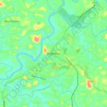
Name: Topografische Karte Nilambur, Höhe, Relief.
Ort: Nilambur, Malappuram, Kerala, 679329, India (11.24651 76.20074 11.32651 76.28074)
Durchschnittliche Höhe: 33 m
Minimale Höhe: 6 m
Maximale Höhe: 103 m
The 2,554 m (8,379 ft) m high Mukurthi peak, which is situated in the border of Nilambur Taluk and Ooty Taluk, and is also the fifth-highest peak in South India as well as the third-highest in Kerala after Anamudi (2,696 m ) and Meesapulimala (2,651 m ), is the highest point of elevation in Malappuram district. It is also the highest peak in Kerala outside the Idukki district. The 2,383 m (7,818 ft) high Anginda peak, which is located closer to Malappuram-Palakkad-Nilgiris district border is the second-highest peak. Vavul Mala, a 2,339 m high peak situated on the trijunction of Nilambur Taluk of Malappuram, Wayanad, and Thamarassery Taluk of Kozhikode districts, is the third-highest point of elevation in the district. The Nilambur Taluk has several small and medium-sized tributaries of Chaliyar river.