Topografische Karte Ballynahinch
Klicken Sie auf die Karte, um die Höhe anzuzeigen.
Ballynahinch
"Roads Service approved the stage 2 preferred options report for the scheme, including the recommendation for a preferred line for the A24 Ballynahinch bypass scheme around the eastern outskirts and adjacent to the development limit of the town. That line will run from the junction of the A24 Belfast Road and the A21 Saintfield Road, which is north of the town, to the junction of the A24 Drumaness Road and the B2 Downpatrick Road, which is south of the town, at a distance of approximately 3.1 km. The scheme will involve substantial earthworks to traverse the drumlin topography and ground conditions along the route, which includes the flood plain of the Ballynahinch River. Three substantial structures will be required where the route crosses Moss Road, Crossgar Road and the Ballynahinch river."
Über diese Karte
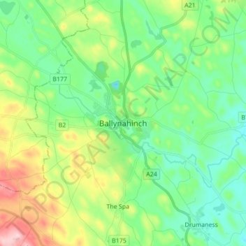
Name: Topografische Karte Ballynahinch, Höhe, Relief.
Durchschnittliche Höhe: 99 m
Minimale Höhe: 37 m
Maximale Höhe: 244 m
Andere topografische Karten
Klicken Sie auf eine Karte, um ihre Topografie, ihre Höhe und ihr Relief anzuzeigen.


County Antrim
United Kingdom > Northern Ireland
A large portion of Antrim is hilly, especially in the east, where the highest elevations are attained. The range runs north and south, and, following this direction, the highest points are Knocklayd 514 m (1,690 ft), Slieveanorra 508 m (1,670 ft), Trostan 550 m (1,800 ft), Slemish 437 m (1,430 ft), Agnew's…
Durchschnittliche Höhe: 70 m











Mid and East Antrim District
United Kingdom > Northern Ireland > County Antrim
Durchschnittliche Höhe: 111 m


Botanic Gardens
United Kingdom > Northern Ireland > County Antrim > Belfast
Durchschnittliche Höhe: 15 m