
Topografische Karte Clent
Interaktive Karte
Klicken Sie auf die Karte, um die Höhe anzuzeigen.
Über diese Karte
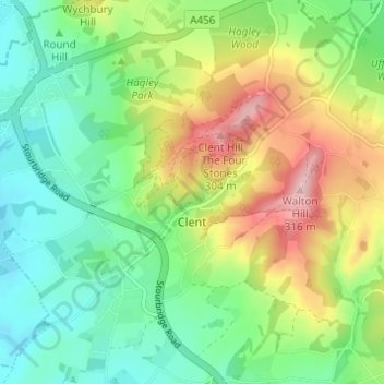
Name: Topografische Karte Clent, Höhe, Relief.
Ort: Clent, Bromsgrove, Worcestershire, England, United Kingdom (52.39945 -2.13824 52.43095 -2.07696)
Durchschnittliche Höhe: 183 m
Minimale Höhe: 111 m
Maximale Höhe: 312 m
Because of the hilly topography of the parish the village consists of several distinct hamlets. These are Upper Clent (Clatterbach and the area around the parish church of St. Leonard), Lower Clent, Holy Cross, Adams Hill and Walton Pool.[2] The Civil Parish of Clent also included part of the village of West Hagley, the population of which is about half that of the whole parish. On the first of April 2016, this part of the parish was transferred to the Parish of Hagley. Though in the ancient ecclesiastical parish of Clent, that area is now part of the Anglican parish of Broome. Part of the parish is an area of agricultural lowland, but to the northwest the ground rises forming the Clent Hills (now owned by the National Trust), which is a popular destination for walkers.
Andere topografische Karten
Klicken Sie auf eine Karte, um ihre Topografie, ihre Höhe und ihr Relief anzuzeigen.
Major's Green
United Kingdom > England > Worcestershire > Bromsgrove > Wythall CP
Major's Green, Wythall CP, Bromsgrove, Worcestershire, England, B90 1DH, United Kingdom
Durchschnittliche Höhe: 146 m
Hunnington CP
United Kingdom > England > Worcestershire > Bromsgrove
Hunnington CP, Bromsgrove, Worcestershire, England, United Kingdom
Durchschnittliche Höhe: 165 m
Beacon Wood
United Kingdom > England > Worcestershire > Bromsgrove > Lydiate Ash
Beacon Wood, Lickey and Blackwell CP, Lydiate Ash, Bromsgrove, Worcestershire, England, United Kingdom
Durchschnittliche Höhe: 210 m
Tanner's Green
United Kingdom > England > Worcestershire > Bromsgrove > Wythall CP
Tanner's Green, Wythall CP, Bromsgrove, Worcestershire, England, B47 6BE, United Kingdom
Durchschnittliche Höhe: 158 m
Finstall CP
United Kingdom > England > Worcestershire > Bromsgrove
Finstall CP, Bromsgrove, Worcestershire, England, United Kingdom
Durchschnittliche Höhe: 110 m
Lickey Hills Country Park
United Kingdom > England > Worcestershire > Bromsgrove > Cofton Hackett CP
Lickey Hills Country Park, Cofton Hackett CP, Rubery, Bromsgrove, Worcestershire, England, United Kingdom
Durchschnittliche Höhe: 208 m
Clent Hills
United Kingdom > England > Worcestershire > Bromsgrove > Clent
Clent Hills, Clent, Bromsgrove, Worcestershire, England, DY9 9PG, United Kingdom
Durchschnittliche Höhe: 210 m
Barnt Green CP
United Kingdom > England > Worcestershire > Bromsgrove
Barnt Green CP, Bromsgrove, Worcestershire, England, United Kingdom
Durchschnittliche Höhe: 176 m
Romsley CP
United Kingdom > England > Worcestershire > Bromsgrove
Romsley CP, Bromsgrove, Worcestershire, England, United Kingdom
Durchschnittliche Höhe: 205 m
Blackwell
United Kingdom > England > Worcestershire > Bromsgrove > Blackwell
Blackwell, Bromsgrove, Worcestershire, West Midlands, England, B60 1BG, United Kingdom
Durchschnittliche Höhe: 162 m
Belbroughton CP
United Kingdom > England > Worcestershire > Bromsgrove
Belbroughton CP, Bromsgrove, Worcestershire, England, United Kingdom
Durchschnittliche Höhe: 130 m
Tardebigge
United Kingdom > England > Worcestershire > Bromsgrove
Tardebigge, Bromsgrove, Worcestershire, England, B60 1ND, United Kingdom
Durchschnittliche Höhe: 136 m
Hollywood
United Kingdom > England > Worcestershire > Bromsgrove
Hollywood, Bromsgrove, Worcestershire, England, B47 5JN, United Kingdom
Durchschnittliche Höhe: 157 m
Bournheath CP
United Kingdom > England > Worcestershire > Bromsgrove > Bournheath CP
Bournheath CP, Bromsgrove, Worcestershire, West Midlands, England, United Kingdom
Durchschnittliche Höhe: 147 m
Alvechurch CP
United Kingdom > England > Worcestershire > Bromsgrove
Alvechurch CP, Bromsgrove, Worcestershire, England, United Kingdom
Durchschnittliche Höhe: 156 m
Rubery
United Kingdom > England > Worcestershire > Bromsgrove
Rubery, Bromsgrove, Worcestershire, England, B45 9DD, United Kingdom
Durchschnittliche Höhe: 213 m
Wythall CP
United Kingdom > England > Worcestershire > Bromsgrove
Wythall CP, Bromsgrove, Worcestershire, England, United Kingdom
Durchschnittliche Höhe: 155 m
Catshill
United Kingdom > England > Worcestershire > Bromsgrove > Catshill
Catshill, Bromsgrove, Worcestershire, West Midlands, England, B61 0NT, United Kingdom
Durchschnittliche Höhe: 151 m
Frankley CP
United Kingdom > England > Worcestershire > Bromsgrove
Frankley CP, Bromsgrove, Worcestershire, England, United Kingdom
Durchschnittliche Höhe: 194 m
Lydiate Ash
United Kingdom > England > Worcestershire > Bromsgrove
Lydiate Ash, Bromsgrove, Worcestershire, England, B61 0HU, United Kingdom
Durchschnittliche Höhe: 186 m
Gay Hill
United Kingdom > England > Worcestershire > Bromsgrove
Gay Hill, Bromsgrove, Worcestershire, England, B38 0DH, United Kingdom
Durchschnittliche Höhe: 176 m
Cofton Hackett CP
United Kingdom > England > Worcestershire > Bromsgrove
Cofton Hackett CP, Bromsgrove, Worcestershire, England, United Kingdom
Durchschnittliche Höhe: 200 m