
Spenden
Rüsten Sie sich für Ihr nächstes Abenteuer:
Als Amazon-Partner erhält diese Website eine Provision für qualifizierte Käufe, ohne zusätzliche Kosten für Sie.
Topografische Karte Fredericton
Klicken Sie auf die Karte, um die Höhe anzuzeigen.
Spenden
Rüsten Sie sich für Ihr nächstes Abenteuer:
Als Amazon-Partner erhält diese Website eine Provision für qualifizierte Käufe, ohne zusätzliche Kosten für Sie.
Fredericton
At an altitude of about 17 m (56 ft) above sea level, Fredericton is nestled in the Pennsylvanian Basin. It differs markedly from the geologically older parts of the province. There are prominently two distinct areas in the region that are divided around the area of Wilsey Road, in the east end of the city. In the west side, the bedrock underneath the earth is topographically dominant, whereas the other is controlled by Pleistocene and recent deposits leading to the rivers (resulting in the area being shallow and wide). Fredericton and its surroundings are rich in water resources, which, coupled with highly arable soil, make the Fredericton region ideal for agriculture. The Saint John River and one of its major tributaries, the Nashwaak River, come together in Fredericton. The uninhabited parts of the city are heavily forested.
Spenden
Rüsten Sie sich für Ihr nächstes Abenteuer:
Als Amazon-Partner erhält diese Website eine Provision für qualifizierte Käufe, ohne zusätzliche Kosten für Sie.
Über diese Karte
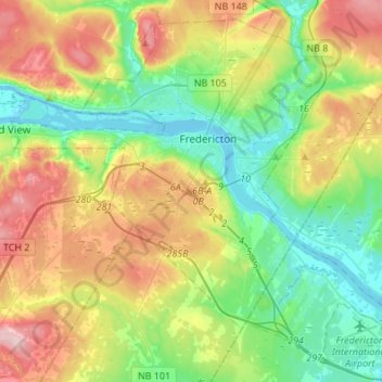
Name: Topografische Karte Fredericton, Höhe, Relief.
Durchschnittliche Höhe: 72 m
Minimale Höhe: -2 m
Maximale Höhe: 196 m
Spenden
Rüsten Sie sich für Ihr nächstes Abenteuer:
Als Amazon-Partner erhält diese Website eine Provision für qualifizierte Käufe, ohne zusätzliche Kosten für Sie.