
Topografische Karte Aberdovey
Interaktive Karte
Klicken Sie auf die Karte, um die Höhe anzuzeigen.
Über diese Karte
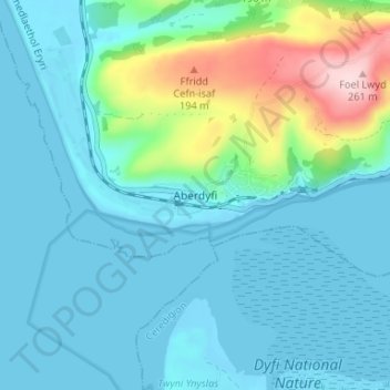
Name: Topografische Karte Aberdovey, Höhe, Relief.
Ort: Aberdovey, Gwynedd, Wales, LL35 0NT, United Kingdom (52.52512 -4.07336 52.56512 -4.03336)
Durchschnittliche Höhe: 46 m
Minimale Höhe: -2 m
Maximale Höhe: 257 m
Andere topografische Karten
Klicken Sie auf eine Karte, um ihre Topografie, ihre Höhe und ihr Relief anzuzeigen.
Parc Tan-y-Bwlch
United Kingdom > Wales > Gwynedd > Mynydd Llandygái > Pen Y Bwlch
Durchschnittliche Höhe: 293 m
Carneddau
United Kingdom > Wales > Gwynedd > Abergwyngregyn
The plants growing on the Carneddau need to be extremely hardy to withstand the snow, frosts, and gales they will encounter during the year and those found by sheltered streams in the valleys are very different from those clinging to crevices on windswept rocks. Sheep graze the mountains and impact the…
Durchschnittliche Höhe: 408 m
Morfa Harlech National Nature Reserve
United Kingdom > Wales > Gwynedd > Harlech
Durchschnittliche Höhe: 3 m
Llyn Gwynant
United Kingdom > Wales > Gwynedd > Beddgelert > Nantgwynant
Durchschnittliche Höhe: 245 m