
Topografische Karte Uttar Pradesh
Interaktive Karte
Klicken Sie auf die Karte, um die Höhe anzuzeigen.
Über diese Karte
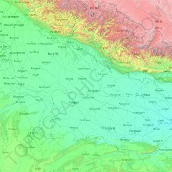
Name: Topografische Karte Uttar Pradesh, Höhe, Relief.
Ort: Uttar Pradesh, India (23.87063 77.08388 30.40638 84.63451)
Durchschnittliche Höhe: 954 m
Minimale Höhe: 47 m
Maximale Höhe: 7.878 m
Uttar Pradesh, with a total area of 243,290 square kilometres (93,935 sq mi), is India's fourth-largest state in terms of land area and is roughly of same size as United Kingdom. It is situated on the northern spout of India and shares an international boundary with Nepal. The Himalayas border the state on the north, but the plains that cover most of the state are distinctly different from those high mountains. The larger Gangetic Plain region is in the north; it includes the Ganges-Yamuna Doab, the Ghaghra plains, the Ganges plains and the Terai. The smaller Vindhya Range and plateau region are in the south. It is characterised by hard rock strata and a varied topography of hills, plains, valleys and plateaus. The Bhabhar tract gives place to the terai area which is covered with tall elephant grass and thick forests interspersed with marshes and swamps. The sluggish rivers of the bhabhar deepen in this area, their course running through a tangled mass of thick undergrowth. The terai runs parallel to the bhabhar in a thin strip. The entire alluvial plain is divided into three sub-regions. The first in the eastern tract consisting of 14 districts which are subject to periodical floods and droughts and have been classified as scarcity areas. These districts have the highest density of population which gives the lowest per capita land. The other two regions, the central and the western, are comparatively better with a well-developed irrigation system. They suffer from waterlogging and large-scale user tracts. In addition, the area is fairly arid. The state has more than 32 large and small rivers; of them, the Ganga, Yamuna, Saraswati, Sarayu, Betwa, and Ghaghara are larger and of religious importance in Hinduism.
Andere topografische Karten
Klicken Sie auf eine Karte, um ihre Topografie, ihre Höhe und ihr Relief anzuzeigen.
Chennai
India > Tamil Nadu > Chennai
Chennai, Chennai District, Tamil Nadu, India
Durchschnittliche Höhe: 8 m
Bengaluru
India > Karnataka > Bangalore North
Bengaluru, Bangalore North, Bengaluru Urban District, Karnataka, India
Durchschnittliche Höhe: 881 m
3d
India > Rajasthan > Ganganagar Tehsil > 1 LNP
3d, 1 LNP, Ganganagar Tehsil, Sri Ganganagar District, Rajasthan, India
Durchschnittliche Höhe: 178 m
Pallapalayam - Kannampalayam Canal
India > Tamil Nadu > Sulur > Kannampalayam
Pallapalayam - Kannampalayam Canal, Papampatti Pirivu, Kannampalayam, Sulur, Coimbatore District, Tamil Nadu, 641402, India
Durchschnittliche Höhe: 381 m
Coimbatore
India > Tamil Nadu > Coimbatore North
Coimbatore, Coimbatore North, Coimbatore District, Tamil Nadu, 641001, India
Durchschnittliche Höhe: 452 m
Kannampalayam
India > Tamil Nadu > Mathavaram
Kannampalayam, Mathavaram, Thiruvallur District, Tamil Nadu, 600066, India
Durchschnittliche Höhe: 7 m
Bachupally mandal
Bachupally mandal, Medchal–Malkajgiri District, Telangana, 500090, India
Durchschnittliche Höhe: 593 m
Prayagraj
India > Uttar Pradesh > Prayagraj
Prayagraj, Prayagraj District, Uttar Pradesh, 211001, India
Durchschnittliche Höhe: 91 m
Kolkata
Kolkata, Kolkata District, West Bengal, 700073, India
Durchschnittliche Höhe: 5 m
North Sentinel Island
India > Andaman and Nicobar Islands > Ferrargunj
North Sentinel Island, Ferrargunj, South Andaman District, Andaman and Nicobar Islands, India
Durchschnittliche Höhe: 20 m
Gurgaon
India > Haryana > Gurugram District
Gurgaon, Gurugram District, Haryana, India
Durchschnittliche Höhe: 237 m
Kodaikanal
Kodaikanal, Dindigul District, Tamil Nadu, India
Durchschnittliche Höhe: 869 m
Mysuru
India > Karnataka > Mysuru taluk
Mysuru, Mysuru taluk, Mysuru District, Karnataka, 570001, India
Durchschnittliche Höhe: 727 m
Kottakombur
Kottakombur, Devikulam, Idukki District, Kerala, India
Durchschnittliche Höhe: 1.919 m
Pune
India > Maharashtra > Pune City > Pune
Pune, Pune City, Pune District, Maharashtra, 411001, India
Durchschnittliche Höhe: 641 m
Akpa
India > Himachal Pradesh > Moorang
Akpa, Moorang, Kinnaur District, Himachal Pradesh, 172116, India
Durchschnittliche Höhe: 2.709 m
Western Ghats
Western Ghats, Idukki, Kerala, 685614, India
Durchschnittliche Höhe: 2.225 m
Mat
India > Uttar Pradesh > Mathura District
Mat, Mathura District, Uttar Pradesh, India
Durchschnittliche Höhe: 182 m
Maduranthakam
Maduranthakam, Chengalpattu District, Tamil Nadu, India
Durchschnittliche Höhe: 37 m
Thiruvananthapuram
India > Kerala > Thiruvananthapuram
Thiruvananthapuram, Thiruvananthapuram District, Kerala, 695001, India
Durchschnittliche Höhe: 33 m
Srinagar
India > Jammu and Kashmir > Srinagar (South)
Srinagar, Srinagar (South), Srinagar District, Jammu and Kashmir, 190001, India
Durchschnittliche Höhe: 1.805 m
Vijayawada
India > Andhra Pradesh > Vijayawada (Urban)
Vijayawada, Vijayawada (Urban), NTR District, Andhra Pradesh, 520001, India
Durchschnittliche Höhe: 36 m
Kolhapur district
Kolhapur district, Maharashtra, India
Durchschnittliche Höhe: 464 m