
Topografische Karte Udupi
Interaktive Karte
Klicken Sie auf die Karte, um die Höhe anzuzeigen.
Über diese Karte
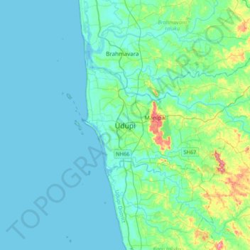
Name: Topografische Karte Udupi, Höhe, Relief.
Ort: Udupi, Udupi taluku, Udupi District, Karnataka, 576101, India (13.18192 74.58732 13.50192 74.90732)
Durchschnittliche Höhe: 17 m
Minimale Höhe: -4 m
Maximale Höhe: 121 m
Udupi has an elevation of 27 m (89 ft) above mean sea level. The climate in Udupi is hot in summers and pleasant in winter. During summers (from March to May) the temperature reaches up to 38 °C (100 °F) and in winters (from December to February) it is usually between 32 and 20 °C (90 and 68 °F). As it is a coastal area, there are a few beaches which are tourist attractions. Kaup beach, Malpe beach are two of the beaches in Udupi.
Andere topografische Karten
Klicken Sie auf eine Karte, um ihre Topografie, ihre Höhe und ihr Relief anzuzeigen.
Suvarna
India > Karnataka > Udupi taluku
Suvarna, Udupi taluku, Udupi District, Karnataka, India
Durchschnittliche Höhe: 133 m
Herga
India > Karnataka > Udupi taluku
Herga, Udupi taluku, Udupi District, Karnataka, 576104, India
Durchschnittliche Höhe: 32 m
Manipal
India > Karnataka > Udupi taluku
Manipal, Udupi taluku, Udupi district, Karnataka, 576104, India
Durchschnittliche Höhe: 32 m