
Topografische Karte MRC Les Pays-d'En-Haut - sommet
Interaktive Karte
Klicken Sie auf die Karte, um die Höhe anzuzeigen.
Über diese Karte
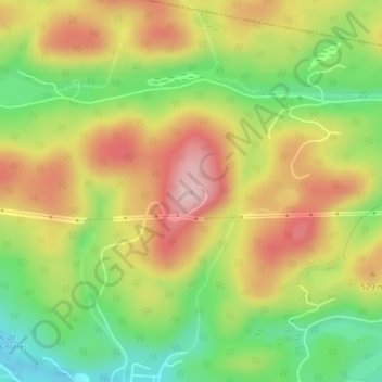
Name: Topografische Karte MRC Les Pays-d'En-Haut - sommet, Höhe, Relief.
Durchschnittliche Höhe: 478 m
Minimale Höhe: 363 m
Maximale Höhe: 594 m
Andere topografische Karten
Klicken Sie auf eine Karte, um ihre Topografie, ihre Höhe und ihr Relief anzuzeigen.
Lac Dépatie
Canada > Québec > Saint-Adolphe-d'Howard
Lac Dépatie, Saint-Adolphe-d'Howard, Les Pays-d'en-Haut, Laurentides, Québec, Canada
Durchschnittliche Höhe: 423 m
Mont-Howard
Canada > Québec > Saint-Adolphe-d'Howard
Mont-Howard, Saint-Adolphe-d'Howard, Les Pays-d'en-Haut, Laurentides, Québec, J0T 2B0, Canada
Durchschnittliche Höhe: 412 m
Domaine-des-Quatre-Lacs
Canada > Québec > Saint-Adolphe-d'Howard
Domaine-des-Quatre-Lacs, Saint-Adolphe-d'Howard, Les Pays-d'en-Haut, Laurentides, Québec, J0T 2B0, Canada
Durchschnittliche Höhe: 429 m
Lac-Saint-Denis
Canada > Québec > Saint-Adolphe-d'Howard
Lac-Saint-Denis, Saint-Adolphe-d'Howard, Les Pays-d'en-Haut, Laurentides, Québec, J0T 2B0, Canada
Durchschnittliche Höhe: 419 m
Lac-Vert
Canada > Québec > Saint-Adolphe-d'Howard
Lac-Vert, Saint-Adolphe-d'Howard, Les Pays-d'en-Haut, Laurentides, Québec, J0T 2B0, Canada
Durchschnittliche Höhe: 437 m
Club de Plein Air Saint Adolphe d'Howard
Canada > Québec > Saint-Adolphe-d'Howard
Club de Plein Air Saint Adolphe d'Howard, Saint-Adolphe-d'Howard, Les Pays-d'en-Haut, Laurentides, Québec, Canada
Durchschnittliche Höhe: 399 m
Lac Schmidt
Canada > Québec > Saint-Adolphe-d'Howard
Lac Schmidt, Chemin de la Châtelaine, Saint-Adolphe-d'Howard, Les Pays-d'en-Haut, Laurentides, Québec, J0T 2B0, Canada
Durchschnittliche Höhe: 400 m
Lac Pékan
Canada > Québec > Saint-Adolphe-d'Howard
Lac Pékan, Chemin du Renard, Saint-Adolphe-d'Howard, Les Pays-d'en-Haut, Laurentides, Québec, J0T 2B0, Canada
Durchschnittliche Höhe: 444 m