Geolokalisieren

Topografische Karte Cork

Interaktive Karte

Klicken Sie auf die Karte, um die Höhe anzuzeigen.

Über diese Karte

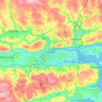
Name: Topografische Karte Cork, Höhe, Relief.

Ort: Cork, County Cork, Munster, Irland (51.82731 -8.63785 51.97014 -8.35513)

Durchschnittliche Höhe: 79 m

Minimale Höhe: -3 m

Maximale Höhe: 197 m

Andere topografische Karten

Klicken Sie auf eine Karte, um ihre Topografie, ihre Höhe und ihr Relief anzuzeigen.

West Cork

Irland > County Cork

West Cork, County Cork, Munster, Irland

Durchschnittliche Höhe: 83 m

The Municipal District of Kanturk – Mallow

Irland > County Cork

The Municipal District of Kanturk – Mallow, County Cork, Munster, Irland

Durchschnittliche Höhe: 182 m

Tullagreen

Irland > County Cork > Municipal District of Cobh

Tullagreen, Carrigtohill ED, Municipal District of Cobh, County Cork, Munster, Irland

Durchschnittliche Höhe: 12 m