
Topografische Karte Rother
Interaktive Karte
Klicken Sie auf die Karte, um die Höhe anzuzeigen.
Über diese Karte
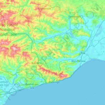
Name: Topografische Karte Rother, Höhe, Relief.
Ort: Rother, East Sussex, England, United Kingdom (50.81919 0.32156 51.08365 0.86786)
Durchschnittliche Höhe: 36 m
Minimale Höhe: -2 m
Maximale Höhe: 193 m
Andere topografische Karten
Klicken Sie auf eine Karte, um ihre Topografie, ihre Höhe und ihr Relief anzuzeigen.
Threeleg Cross
United Kingdom > England > East Sussex > Rother > Ticehurst
Durchschnittliche Höhe: 94 m
Darwell Wood
United Kingdom > England > East Sussex > Rother > Netherfield
Durchschnittliche Höhe: 91 m
Battle of Hastings
United Kingdom > England > East Sussex > Rother > Catsfield
Battle Abbey was founded by William at the site of the battle. According to 12th-century sources, William made a vow to found the abbey, and the high altar of the church was placed at the site where Harold had died. More likely, the foundation was imposed on William by papal legates in 1070. The topography of…
Durchschnittliche Höhe: 60 m
Cooden Rocks
United Kingdom > England > East Sussex > Rother > Bexhill-on-Sea
Durchschnittliche Höhe: 5 m
Offham Hill
United Kingdom > England > East Sussex > Lewes > Offham > Hamsey
Durchschnittliche Höhe: 60 m
Sheffield Green
United Kingdom > England > East Sussex > Wealden > Sheffield Park
Durchschnittliche Höhe: 50 m
Combe Haven
United Kingdom > England > East Sussex > Rother > Bexhill-on-Sea
Durchschnittliche Höhe: 27 m
Ashdown Forest
United Kingdom > England > East Sussex > Wealden
Ashdown Forest is an ancient area of open heathland occupying the highest sandy ridge-top of the High Weald Area of Outstanding Natural Beauty. It is situated 30 miles (48 km) south of London in the county East Sussex, England. Rising to an elevation of 732 feet (223 m) above sea level, its heights provide…
Durchschnittliche Höhe: 117 m
Milton Street
United Kingdom > England > East Sussex > Wealden > Wilmington
Durchschnittliche Höhe: 45 m
Belle Tout lighthouse
United Kingdom > England > East Sussex > Eastbourne
Durchschnittliche Höhe: 27 m
Burgh Hill
United Kingdom > England > East Sussex > Wealden > Muddles Green
Durchschnittliche Höhe: 30 m
The Dicker
United Kingdom > England > East Sussex > Wealden > Upper Dicker
Durchschnittliche Höhe: 21 m
Northbridge Street
United Kingdom > England > East Sussex > Rother > Robertsbridge
Durchschnittliche Höhe: 40 m
Shipyard Pett
United Kingdom > England > East Sussex > Wealden > Forest Row
Durchschnittliche Höhe: 90 m
Punnetts Town Recreation Ground
United Kingdom > England > East Sussex > Wealden > Punnett's Town > Chapel Cross
Durchschnittliche Höhe: 125 m
Chuck Hatch
United Kingdom > England > East Sussex > Wealden > Upper Hartfield
Durchschnittliche Höhe: 112 m
Broadwater Warren Nature Reserve
United Kingdom > England > East Sussex > Wealden > Groombridge
Durchschnittliche Höhe: 84 m
Old Heathfield
United Kingdom > England > East Sussex > Wealden > Cade Street
Durchschnittliche Höhe: 119 m
Heathfield Park
United Kingdom > England > East Sussex > Wealden > Cade Street
Durchschnittliche Höhe: 132 m
Frant Lakes
United Kingdom > England > East Sussex > Wealden > Bells Yew Green
Durchschnittliche Höhe: 110 m
Cousley Wood
United Kingdom > England > East Sussex > Wealden > Woods Green
Durchschnittliche Höhe: 108 m
Three Cups Corner
United Kingdom > England > East Sussex > Wealden District > Punnett's Town
Durchschnittliche Höhe: 110 m
Kingston Near Lewes
United Kingdom > England > East Sussex > Lewes > Kingston Near Lewes
Durchschnittliche Höhe: 65 m
Ditchling Beacon
United Kingdom > England > East Sussex > Lewes
Ditchling Beacon is the highest point in East Sussex, England, with an elevation of 248 m (814 ft). It is south of Ditchling and to the north-east of Brighton. It is a large chalk hill with a particularly steep northern face, covered with open grassland and sheep-grazing areas. It is the third-highest point on…
Durchschnittliche Höhe: 144 m
Chalvington
United Kingdom > England > East Sussex > Wealden District > Chalvington
Durchschnittliche Höhe: 19 m
Furner's Green
United Kingdom > England > East Sussex > Wealden District > Danehill > Furner's Green
Durchschnittliche Höhe: 62 m