
Topografische Karte Isle Royale
Interaktive Karte
Klicken Sie auf die Karte, um die Höhe anzuzeigen.
Über diese Karte
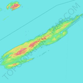
Name: Topografische Karte Isle Royale, Höhe, Relief.
Ort: Isle Royale, Keweenaw County, Michigan, United States (47.82376 -89.23555 48.19102 -88.42232)
Durchschnittliche Höhe: 190 m
Minimale Höhe: 176 m
Maximale Höhe: 443 m
According to the Köppen climate classification system, Isle Royale National Park has a mild summer Humid continental climate (Dfb). According to the United States Department of Agriculture, the Plant Hardiness zone is 4b at 1178 ft (359 m) elevation with an average annual extreme minimum temperature of -24.2 °F (-31.2 °C).
Andere topografische Karten
Klicken Sie auf eine Karte, um ihre Topografie, ihre Höhe und ihr Relief anzuzeigen.
Eagle Harbor Township
United States > Michigan > Keweenaw County
Eagle Harbor Township, Keweenaw County, Michigan, United States
Durchschnittliche Höhe: 190 m
Mohawk
United States > Michigan > Keweenaw County
Mohawk, Allouez Township, Keweenaw County, Michigan, 49901, United States
Durchschnittliche Höhe: 300 m
Eagle Harbor
United States > Michigan > Keweenaw County
Eagle Harbor, Eagle Harbor Township, Keweenaw County, Michigan, United States
Durchschnittliche Höhe: 200 m
Allouez
United States > Michigan > Keweenaw County
Allouez, Allouez Township, Keweenaw County, Michigan, 49805, United States
Durchschnittliche Höhe: 301 m
Isle Royale National Park
United States > Michigan > Keweenaw County
Isle Royale National Park, Keweenaw County, Michigan, United States
Durchschnittliche Höhe: 189 m
Gay
United States > Michigan > Keweenaw County > Gay
Gay, Sherman Township, Keweenaw County, Michigan, United States
Durchschnittliche Höhe: 188 m
Copper Harbor
United States > Michigan > Keweenaw County
Copper Harbor, Grant Township, Keweenaw County, Michigan, 49918, United States
Durchschnittliche Höhe: 220 m