
Topografische Karte Taos
Interaktive Karte
Klicken Sie auf die Karte, um die Höhe anzuzeigen.
Über diese Karte
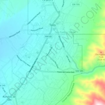
Name: Topografische Karte Taos, Höhe, Relief.
Ort: Taos, Taos County, New Mexico, United States (36.35496 -105.60605 36.42347 -105.55629)
Durchschnittliche Höhe: 2.180 m
Minimale Höhe: 2.066 m
Maximale Höhe: 2.739 m
The elevation of the town is 6,969 feet (2,124 m). Just north of Taos is Wheeler Peak, at 13,161 feet (4,011 m), the highest point in New Mexico. Taos has a warm-summer humid continental climate (Köppen Dfb), though it borders on a semi-arid climate (BSk) due to the low rainfall. The town is characterized by extreme diurnal variations of temperature. Even when summer days get extremely hot, nights cool off considerably.
Andere topografische Karten
Klicken Sie auf eine Karte, um ihre Topografie, ihre Höhe und ihr Relief anzuzeigen.
Ojo Caliente
United States > New Mexico > Taos County
Ojo Caliente, Taos County, New Mexico, 87549, United States
Durchschnittliche Höhe: 1.950 m
Taos Ski Valley
United States > New Mexico > Taos County
Taos Ski Valley, Taos County, New Mexico, United States
Durchschnittliche Höhe: 3.229 m
Anderson Park
United States > New Mexico > Taos County
Anderson Park, Taos County, New Mexico, United States
Durchschnittliche Höhe: 3.219 m
Guadalupe Mountain
United States > New Mexico > Taos County
Guadalupe Mountain, Taos County, New Mexico, 87519, United States
Durchschnittliche Höhe: 2.448 m
Sipapu
United States > New Mexico > Taos County
Sipapu, Taos County, New Mexico, United States
Durchschnittliche Höhe: 2.754 m
Taos Ski Valley
United States > New Mexico > Taos County
Taos Ski Valley, Taos County, New Mexico, United States
Durchschnittliche Höhe: 3.307 m
Gold Hill
United States > New Mexico > Taos County
Gold Hill, Taos County, New Mexico, United States
Durchschnittliche Höhe: 3.568 m
Tres Piedras
United States > New Mexico > Taos County
Tres Piedras, Taos County, New Mexico, United States
Durchschnittliche Höhe: 2.476 m
Cabresto Lake
United States > New Mexico > Taos County
Cabresto Lake, Taos County, New Mexico, United States
Durchschnittliche Höhe: 2.933 m
Arroyo Hondo
United States > New Mexico > Taos County
Arroyo Hondo, Taos County, New Mexico, 87513, United States
Durchschnittliche Höhe: 2.135 m
Ute Mountain
United States > New Mexico > Taos County
Ute Mountain, Taos County, New Mexico, United States
Durchschnittliche Höhe: 2.775 m
Red River
United States > New Mexico > Taos County
Red River, Taos County, New Mexico, 57558, United States
Durchschnittliche Höhe: 2.812 m
Ranchos de Taos
United States > New Mexico > Taos County
Ranchos de Taos, Taos County, New Mexico, 87550, United States
Durchschnittliche Höhe: 2.119 m
San Cristobal
United States > New Mexico > Taos County
San Cristobal, Taos County, New Mexico, 87564, United States
Durchschnittliche Höhe: 2.315 m
Peñasco
United States > New Mexico > Taos County
Peñasco, Taos County, New Mexico, 87553, United States
Durchschnittliche Höhe: 2.355 m
Pot Creek
United States > New Mexico > Taos County
Pot Creek, Taos County, New Mexico, United States
Durchschnittliche Höhe: 2.383 m
Wheeler Peak
United States > New Mexico > Taos County
Wheeler Peak, Taos County, New Mexico, United States
Durchschnittliche Höhe: 3.674 m
Ojito
United States > New Mexico > Taos County
Ojito, Taos County, New Mexico, 87543, United States
Durchschnittliche Höhe: 2.431 m
Questa
United States > New Mexico > Taos County
Questa, Taos County, New Mexico, 87556, United States
Durchschnittliche Höhe: 2.339 m
Carson
United States > New Mexico > Taos County
Carson, Taos County, New Mexico, 87517, United States
Durchschnittliche Höhe: 2.082 m
Rio Hondo
United States > New Mexico > Taos County > Taos Ski Valley
Rio Hondo, Taos Ski Valley, Taos County, New Mexico, 87525, United States
Durchschnittliche Höhe: 3.119 m
Rio Grande Rift Historical Marker
United States > New Mexico > Taos County
Rio Grande Rift Historical Marker, Taos County, New Mexico, United States
Durchschnittliche Höhe: 2.160 m
Red River
United States > New Mexico > Taos County
Red River, Taos County, New Mexico, United States
Durchschnittliche Höhe: 2.846 m
Taos
United States > New Mexico > Taos County > Taos
Taos, Taos County, New Mexico, 87571, United States
Durchschnittliche Höhe: 2.173 m
El Prado
United States > New Mexico > Taos County
El Prado, Taos County, New Mexico, 87571, United States
Durchschnittliche Höhe: 2.145 m