
Topografische Karte Mount Abu
Interaktive Karte
Klicken Sie auf die Karte, um die Höhe anzuzeigen.
Über diese Karte
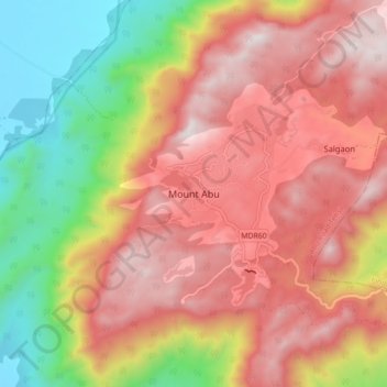
Name: Topografische Karte Mount Abu, Höhe, Relief.
Durchschnittliche Höhe: 914 m
Minimale Höhe: 279 m
Maximale Höhe: 1.422 m
Mount Abu town, the only hill station in Rajasthan, is at an elevation of 1,220 m (4,003 ft). It has been a popular retreat from the heat of Rajasthan and neighboring Gujarat for centuries.
Andere topografische Karten
Klicken Sie auf eine Karte, um ihre Topografie, ihre Höhe und ihr Relief anzuzeigen.
Aravalli Range
India > Rajasthan > Abu Road Tehsil
Aravalli Range, Abu Road Tehsil, Sirohi District, Rajasthan, 307501, India
Durchschnittliche Höhe: 1.339 m
Guru Shikhar, Abu
India > Rajasthan > Abu Road Tehsil
Guru Shikhar, Abu, Abu Road Tehsil, Sirohi District, Rajasthan, 307501, India
Durchschnittliche Höhe: 1.366 m