
Topografische Karte Columbus
Interaktive Karte
Klicken Sie auf die Karte, um die Höhe anzuzeigen.
Über diese Karte
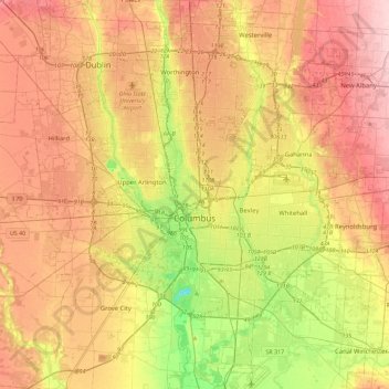
Name: Topografische Karte Columbus, Höhe, Relief.
Ort: Columbus, Franklin County, Ohio, United States (39.80869 -83.21018 40.15731 -82.77131)
Durchschnittliche Höhe: 261 m
Minimale Höhe: 169 m
Maximale Höhe: 343 m
The confluence of the Scioto and Olentangy rivers is just northwest of Downtown Columbus. Several smaller tributaries course through the Columbus metropolitan area, including Alum Creek, Big Walnut Creek and Darby Creek. Columbus is considered to have relatively flat topography thanks to a large glacier that covered most of Ohio during the Wisconsin Ice Age. However, there are sizable differences in elevation through the area, with the high point of Franklin County being 1,132 ft (345 m) above sea level near New Albany, and the low point being 670 ft (200 m) where the Scioto River leaves the county near Lockbourne. Numerous ravines near the rivers and creeks also add variety to the landscape. Tributaries to Alum Creek and the Olentangy River cut through shale, while tributaries to the Scioto River cut through limestone.
Andere topografische Karten
Klicken Sie auf eine Karte, um ihre Topografie, ihre Höhe und ihr Relief anzuzeigen.
Worthington
United States > Ohio > Franklin County
Worthington, Sharon Township, Franklin County, Ohio, 43085, United States
Durchschnittliche Höhe: 262 m
Grandview Heights
United States > Ohio > Franklin County
Grandview Heights, Franklin County, Ohio, United States
Durchschnittliche Höhe: 232 m
Shepard
United States > Ohio > Franklin County > Columbus
Shepard, Columbus, Franklin County, Ohio, 43129, United States
Durchschnittliche Höhe: 245 m
Madison Township
United States > Ohio > Franklin County
Madison Township, Franklin County, Ohio, United States
Durchschnittliche Höhe: 232 m
Dublin
United States > Ohio > Franklin County
Dublin, Washington Township, Franklin County, Ohio, United States
Durchschnittliche Höhe: 275 m
Columbus
United States > Ohio > Franklin County > Columbus
Columbus, Franklin County, Ohio, 43216, United States
Durchschnittliche Höhe: 255 m
Riverlea
United States > Ohio > Franklin County > Riverlea
Riverlea, Sharon Township, Franklin County, Ohio, United States
Durchschnittliche Höhe: 247 m
Bexley
United States > Ohio > Franklin County > Bexley > Bexley
Bexley, Franklin County, Ohio, 43209, United States
Durchschnittliche Höhe: 243 m
Franklin County
United States > Ohio > Franklin County
Franklin County, Ohio, United States
Durchschnittliche Höhe: 262 m
Galloway
United States > Ohio > Franklin County
Galloway, Prairie Township, Franklin County, Ohio, 43119, United States
Durchschnittliche Höhe: 276 m
Bexley
United States > Ohio > Franklin County
Bexley, Franklin County, Ohio, 43209, United States
Durchschnittliche Höhe: 240 m