
Topografische Karte Olango Island
Interaktive Karte
Klicken Sie auf die Karte, um die Höhe anzuzeigen.
Über diese Karte
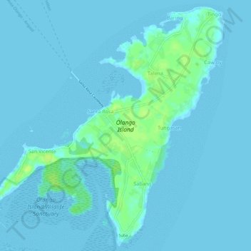
Name: Topografische Karte Olango Island, Höhe, Relief.
Ort: Olango Island, Lapu-Lapu, Cebu, Central Visayas, Philippines (10.23741 124.01964 10.28879 124.07437)
Durchschnittliche Höhe: 2 m
Minimale Höhe: -3 m
Maximale Höhe: 13 m
Andere topografische Karten
Klicken Sie auf eine Karte, um ihre Topografie, ihre Höhe und ihr Relief anzuzeigen.
Mactan
Philippines > Cebu > Lapu-Lapu
Mactan, Lapu-Lapu, Cebu, Central Visayas, Philippines
Durchschnittliche Höhe: 3 m
Gilutongan Island
Philippines > Cebu > Lapu-Lapu
Gilutongan Island, Lapu-Lapu, Cebu, Central Visayas, Philippines
Durchschnittliche Höhe: 0 m
Sulpa Islet
Philippines > Cebu > Lapu-Lapu
Sulpa Islet, Lapu-Lapu, Cebu, Central Visayas, Philippines
Durchschnittliche Höhe: 0 m
Hilutungan Sanctuary
Philippines > Cebu > Lapu-Lapu
Hilutungan Sanctuary, Simean Amodia, Pacific Grand Villas, Lapu-Lapu, Cebu, Central Visayas, 6017, Philippines
Durchschnittliche Höhe: 0 m