Geolokalisieren

Topografische Karte Eastville Park

Interaktive Karte

Klicken Sie auf die Karte, um die Höhe anzuzeigen.

Über diese Karte

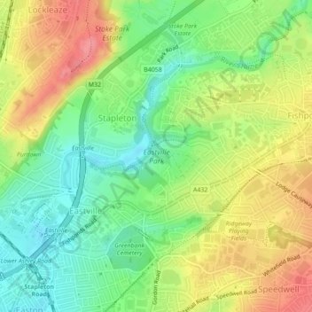
Name: Topografische Karte Eastville Park, Höhe, Relief.

Ort: Eastville Park, Eastville, Bristol, City of Bristol, West of England, England, BS5 6PX, United Kingdom (51.47320 -2.56007 51.48281 -2.53979)

Durchschnittliche Höhe: 47 m

Minimale Höhe: 9 m

Maximale Höhe: 91 m

Andere topografische Karten

Klicken Sie auf eine Karte, um ihre Topografie, ihre Höhe und ihr Relief anzuzeigen.

The Arches

United Kingdom > England > City of Bristol > Bristol

Durchschnittliche Höhe: 50 m

Stoke Park Estate

United Kingdom > England > City of Bristol > Bristol

Durchschnittliche Höhe: 57 m

Troopers Hill

United Kingdom > England > City of Bristol > Bristol

Durchschnittliche Höhe: 56 m

Brandon Hill

United Kingdom > England > City of Bristol > Bristol

Durchschnittliche Höhe: 39 m

Whitchurch Park Ward

United Kingdom > England > City of Bristol > Bristol

Durchschnittliche Höhe: 91 m

Leigh Woods

United Kingdom > England > City of Bristol > Bristol

Durchschnittliche Höhe: 78 m

Floating Harbour

United Kingdom > England > City of Bristol > Bristol

Durchschnittliche Höhe: 22 m