
Topografische Karte Talbot Island
Interaktive Karte
Klicken Sie auf die Karte, um die Höhe anzuzeigen.
Über diese Karte
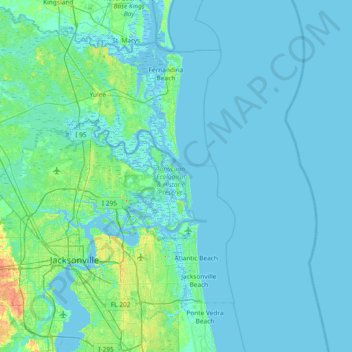
Name: Topografische Karte Talbot Island, Höhe, Relief.
Ort: Talbot Island, Jacksonville, Duval County, Florida, USA (30.16274 -81.76092 30.80274 -81.12092)
Durchschnittliche Höhe: 3 m
Minimale Höhe: -4 m
Maximale Höhe: 32 m
Andere topografische Karten
Klicken Sie auf eine Karte, um ihre Topografie, ihre Höhe und ihr Relief anzuzeigen.
Julington Creek
USA > Florida > Jacksonville
Julington Creek, Jacksonville, Duval County, Florida, 32258, USA
Durchschnittliche Höhe: 6 m
Fort George Island
USA > Florida > Jacksonville
Fort George Island, Jacksonville, Duval County, Florida, 32228, USA
Durchschnittliche Höhe: 3 m
Big Island Swamp
USA > Florida > Jacksonville
Big Island Swamp, Tropea Way North, The Jaxon Apartments, Jacksonville, Duval County, Florida, 32246-6624, USA
Durchschnittliche Höhe: 11 m
Timucuan Ecological & Historic Preserve
USA > Florida > Jacksonville
Timucuan Ecological & Historic Preserve, Big Talbot Island State Park Trail, Jacksonville, Duval County, Florida, USA
Durchschnittliche Höhe: 2 m
Burton Island
USA > Florida > Jacksonville
Burton Island, Jacksonville, Duval County, Florida, USA
Durchschnittliche Höhe: 6 m
Big Talbot Island State Park
USA > Florida > Jacksonville
Big Talbot Island State Park, Jacksonville, Duval County, Florida, USA
Durchschnittliche Höhe: 2 m