
Topografische Karte London Borough of Sutton
Interaktive Karte
Klicken Sie auf die Karte, um die Höhe anzuzeigen.
Über diese Karte
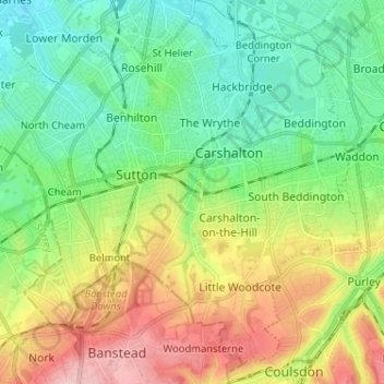
Name: Topografische Karte London Borough of Sutton, Höhe, Relief.
Durchschnittliche Höhe: 71 m
Minimale Höhe: 15 m
Maximale Höhe: 173 m
Andere topografische Karten
Klicken Sie auf eine Karte, um ihre Topografie, ihre Höhe und ihr Relief anzuzeigen.
Richmond
United Kingdom > England > London
The town centre lies just below 33 ft (10m) above sea level. South of the town centre, rising from Richmond Bridge to an elevation of 165 ft (50m), is Richmond Hill. Just beyond the summit of Richmond Hill is Richmond Park, an area of 2,360 acres (9.55 km2; 3.7 sq mi) of wild heath and woodland originally…
Durchschnittliche Höhe: 17 m
Hyde Park
United Kingdom > England > London
"It consists of a screen of handsome fluted Ionic columns, with three carriage entrance archways, two-foot entrances, a lodge, etc. The extent of the whole frontage is about 107 ft (33 m). The central entrance has a bold projection: the entablature is supported by four columns; and the volutes of the capitals…
Durchschnittliche Höhe: 25 m
Gorilla Circus Regents Park Flying Trapeze School
United Kingdom > England > London > Camden Town
Durchschnittliche Höhe: 41 m
Norwood Grove
United Kingdom > England > London
After Anderson died, ownership passed to the Nettlefold family and subsequently to Frederick Nettlefold the brother of Joseph Nettlefold and a member of the family that founded the Nettlefolds Ltd. engineering firm which later became GKN. Nettlefold is commemorated, as a result of his charitable works, by a…
Durchschnittliche Höhe: 58 m
Hyde Park
United Kingdom > England > London > Kensington
"It consists of a screen of handsome fluted Ionic columns, with three carriage entrance archways, two-foot entrances, a lodge, etc. The extent of the whole frontage is about 107 ft (33 m). The central entrance has a bold projection: the entablature is supported by four columns; and the volutes of the capitals…
Durchschnittliche Höhe: 25 m