
Topografische Karte Cockermouth
Interaktive Karte
Klicken Sie auf die Karte, um die Höhe anzuzeigen.
Cockermouth
Cockermouth has a temperate climate that is influenced by the Irish Sea and its low-lying elevation. Cockermouth receives slightly below average rainfall compared with the UK average. Temperatures are also round about average compared with other parts of the UK. The nearest weather station for which online records are available is Aspatria, about 7 miles (11 kilometres) north-northeast of the town centre.
Über diese Karte
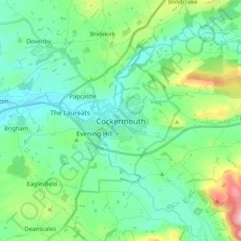
Name: Topografische Karte Cockermouth, Höhe, Relief.
Durchschnittliche Höhe: 105 m
Minimale Höhe: 30 m
Maximale Höhe: 361 m