Geolokalisieren

Topografische Karte Bexhill-on-Sea

Interaktive Karte

Klicken Sie auf die Karte, um die Höhe anzuzeigen.

Über diese Karte

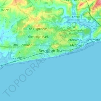
Name: Topografische Karte Bexhill-on-Sea, Höhe, Relief.

Ort: Bexhill-on-Sea, Rother, East Sussex, England, TN39 3JX, United Kingdom (50.80196 0.43091 50.88196 0.51091)

Durchschnittliche Höhe: 13 m

Minimale Höhe: -2 m

Maximale Höhe: 94 m

Andere topografische Karten

Klicken Sie auf eine Karte, um ihre Topografie, ihre Höhe und ihr Relief anzuzeigen.

Battle

United Kingdom > England > East Sussex > Rother > Battle

Durchschnittliche Höhe: 66 m

Burwash

United Kingdom > England > East Sussex > Rother > Burwash

Durchschnittliche Höhe: 83 m

Rye

United Kingdom > England > East Sussex > Rother

The town and its striking surroundings have frequently served as subject for painters, many of whose works are now on display in its art gallery. One of the earliest topographical panoramas, dating from the 17th century when the town was still an island port, is in the style of Hendrick Danckerts and on…

Durchschnittliche Höhe: 7 m

Udimore

United Kingdom > England > East Sussex > Rother

Durchschnittliche Höhe: 23 m

Cooden Rocks

United Kingdom > England > East Sussex > Rother > Bexhill-on-Sea

Durchschnittliche Höhe: 5 m

Combe Haven

United Kingdom > England > East Sussex > Rother > Bexhill-on-Sea

Durchschnittliche Höhe: 27 m

Darwell Reservoir

United Kingdom > England > East Sussex > Rother

Durchschnittliche Höhe: 65 m

Playden

United Kingdom > England > East Sussex > Rother

Durchschnittliche Höhe: 17 m

Ring Wood

United Kingdom > England > East Sussex > Rother > Crowhurst

Durchschnittliche Höhe: 24 m

Bodiam

United Kingdom > England > East Sussex > Rother

Durchschnittliche Höhe: 27 m

Brede

United Kingdom > England > East Sussex > Rother

Durchschnittliche Höhe: 40 m

Icklesham

United Kingdom > England > East Sussex > Rother

Durchschnittliche Höhe: 26 m

Hurst Green

United Kingdom > England > East Sussex > Rother > Hurst Green

Durchschnittliche Höhe: 54 m

Catsfield

United Kingdom > England > East Sussex > Rother > Catsfield

Durchschnittliche Höhe: 53 m

Pett

United Kingdom > England > East Sussex > Rother

Durchschnittliche Höhe: 21 m

Bewl Water

United Kingdom > England > East Sussex > Rother > Ticehurst

Durchschnittliche Höhe: 92 m

Ticehurst

United Kingdom > England > East Sussex > Rother

Durchschnittliche Höhe: 81 m

Sedlescombe

United Kingdom > England > East Sussex > Rother

Durchschnittliche Höhe: 47 m

Battle

United Kingdom > England > East Sussex > Rother > Battle

Durchschnittliche Höhe: 66 m

Northiam

United Kingdom > England > East Sussex > Rother

Durchschnittliche Höhe: 34 m

Peasmarsh

United Kingdom > England > East Sussex > Rother

Durchschnittliche Höhe: 24 m

Camber Sands

United Kingdom > England > East Sussex > Rother > Camber

Durchschnittliche Höhe: 2 m

Fairlight

United Kingdom > England > East Sussex > Rother

Durchschnittliche Höhe: 47 m

Etchingham

United Kingdom > England > East Sussex > Rother

Durchschnittliche Höhe: 46 m

Crowhurst

United Kingdom > England > East Sussex > Rother

Durchschnittliche Höhe: 42 m

Camber

United Kingdom > England > East Sussex > Rother

Durchschnittliche Höhe: 1 m

Whatlington

United Kingdom > England > East Sussex > Rother

Durchschnittliche Höhe: 53 m

Rye

United Kingdom > England > East Sussex > Rother

The town and its striking surroundings have frequently served as subject for painters, many of whose works are now on display in its art gallery. One of the earliest topographical panoramas, dating from the 17th century when the town was still an island port, is in the style of Hendrick Danckerts and on…

Durchschnittliche Höhe: 7 m

Brightling

United Kingdom > England > East Sussex > Rother

Durchschnittliche Höhe: 94 m

Udimore

United Kingdom > England > East Sussex > Rother

Durchschnittliche Höhe: 23 m

Mountfield

United Kingdom > England > East Sussex > Rother

Durchschnittliche Höhe: 63 m