
Topografische Karte Álvaro Obregón
Interaktive Karte
Klicken Sie auf die Karte, um die Höhe anzuzeigen.
Über diese Karte
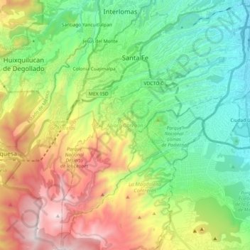
Name: Topografische Karte Álvaro Obregón, Höhe, Relief.
Ort: Álvaro Obregón, Mexico City, Mexico (19.23260 -99.32435 19.40374 -99.17171)
Durchschnittliche Höhe: 2.459 m
Minimale Höhe: 2.231 m
Maximale Höhe: 3.535 m
Álvaro Obregón (Spanish pronunciation: [ˈalvaɾo oβɾeˈɣon]) is a borough (demarcación territorial) in the Mexico City.[3] It contains a large portion of the south-west part of Mexico City. It had a 2010 census population of 727,034 inhabitants and lies at an elevation of 2,319 m. above sea level.
Andere topografische Karten
Klicken Sie auf eine Karte, um ihre Topografie, ihre Höhe und ihr Relief anzuzeigen.
Alameda Central
Alameda Central, Cuauhtémoc, Mexico City, Mexico
Durchschnittliche Höhe: 2.235 m
San Miguel Ajusco
San Miguel Ajusco, Mexico City, 14700, Mexico
Durchschnittliche Höhe: 2.939 m