
Topografische Karte Province of Morropón
Interaktive Karte
Klicken Sie auf die Karte, um die Höhe anzuzeigen.
Über diese Karte
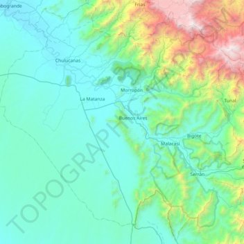
Name: Topografische Karte Province of Morropón, Höhe, Relief.
Ort: Province of Morropón, Piura, Peru (-5.63003 -80.36502 -4.92783 -79.64221)
Durchschnittliche Höhe: 603 m
Minimale Höhe: 60 m
Maximale Höhe: 3.662 m
This province is located in the center of the Piura Region, being a land of contrast and climatic fusion. It is dotted by tropical forests of the dry-equatorial style in its flat areas were the carob tree predominates. In high areas of an elevation 1,500 to 2,000 metres (4,900–6,600 ft) the landscape changes to smooth high jungle and a lack of varied hilly valleys.
Andere topografische Karten
Klicken Sie auf eine Karte, um ihre Topografie, ihre Höhe und ihr Relief anzuzeigen.
Lucarqui
Peru > Piura > Distrito de Ayabaca
Lucarqui, Distrito de Ayabaca, Province of Ayabaca, Piura, Peru
Durchschnittliche Höhe: 1.862 m
Parque Miguel Cortés
Parque Miguel Cortés, Urbanización 4 de Enero, Piura, Province of Piura, Piura, Peru
Durchschnittliche Höhe: 32 m
Cerro Vicús
Peru > Piura > Chulucanas
Cerro Vicús, Chulucanas, Morropón, Piura, Peru
Durchschnittliche Höhe: 171 m
Aypate
Peru > Piura > Distrito de Ayabaca
Aypate, PE-3N, Distrito de Ayabaca, Ayabaca, Piura, Peru
Durchschnittliche Höhe: 2.568 m